Sever-Okapi-Uganda-Final Report-November 2022.pdf
•
0 likes•12 views

Sever, Z. 2022. Looking for Presence of Okapi in the rain forest of QENP, Uganda-Final Report, November 2022.

Recommended
Recommended
More Related Content
More from Zvi Sever
More from Zvi Sever (20)
Recently uploaded
Recently uploaded (20)
Sever-Okapi-Uganda-Final Report-November 2022.pdf
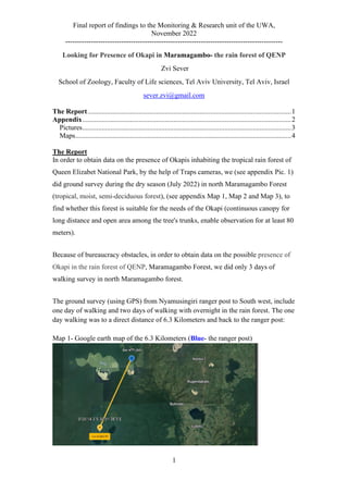
- 1. Final report of findings to the Monitoring & Research unit of the UWA, November 2022 --------------------------------------------------------------------------------------------- 1 Looking for Presence of Okapi in Maramagambo- the rain forest of QENP Zvi Sever School of Zoology, Faculty of Life sciences, Tel Aviv University, Tel Aviv, Israel sever.zvi@gmail.com The Report....................................................................................................................1 Appendix.......................................................................................................................2 Pictures.......................................................................................................................3 Maps...........................................................................................................................4 The Report In order to obtain data on the presence of Okapis inhabiting the tropical rain forest of Queen Elizabet National Park, by the help of Traps cameras, we (see appendix Pic. 1) did ground survey during the dry season (July 2022) in north Maramagambo Forest (tropical, moist, semi-deciduous forest), (see appendix Map 1, Map 2 and Map 3), to find whether this forest is suitable for the needs of the Okapi (continuous canopy for long distance and open area among the tree's trunks, enable observation for at least 80 meters). Because of bureaucracy obstacles, in order to obtain data on the possible presence of Okapi in the rain forest of QENP, Maramagambo Forest, we did only 3 days of walking survey in north Maramagambo forest. The ground survey (using GPS) from Nyamusingiri ranger post to South west, include one day of walking and two days of walking with overnight in the rain forest. The one day walking was to a direct distance of 6.3 Kilometers and back to the ranger post: Map 1- Google earth map of the 6.3 Kilometers (Blue- the ranger post)
- 2. Final report of findings to the Monitoring & Research unit of the UWA, November 2022 --------------------------------------------------------------------------------------------- 2 The two days walking was to a direct distance of 8.6 Kilometers at the first day and at the next day, back to the ranger post: Map 2- Google earth map of the 8.6 Kilometers (Blue- the ranger post) For all the GPS points see the Appendix, maps 4-5. The ground survey produced a sorrowful status of north Maramagambo Forest. There is an illegal activity (see appendix Pic 2) and there are many "windows" in the canopy allowing the sun rays to penetrate and therefor there is a lot of bushes among the old trees, young plantation and sun light on the forest floor (see appendix Pic. 3), resulting in absence of continuous canopy and absence of open area among the tree's trunks. The short time (3 days) should be considered as a limiting factor to get the complete picture of the forest but it is a warning sign for the status of north Maramagambo Forest. Together with my experience with Semuliki N.P. (see my Progress reports November 2015, April 2017 and August 2019) and my article about the Okapi (Sever,20211 ) it might be concluded, that there are no expected okapis in North Maramagambo Forest, therefore we did not used the camera traps in this forest. 1. Sever Z. 2021. Searching for the okapi (Okapia johnstoni) in Semuliki National Park, Uganda. Afr. J. Ecol. 59: 286–292. https://doi.org/10.1111/aje.12796 Appendix Please find presented the next data:
- 3. Final report of findings to the Monitoring & Research unit of the UWA, November 2022 --------------------------------------------------------------------------------------------- 3 Pictures Pic 1 – The team From left: Mr. Meize-the local guide, Dr. Zvi Sever, Mr. Simon Pitter and Mr. Jimmy- soldiers, Mr. Gavi- a ranger. Pic 2 – Illegal camp of illegal fishermen. 2a. There was a food 2b. Salting evidences.
- 4. Final report of findings to the Monitoring & Research unit of the UWA, November 2022 --------------------------------------------------------------------------------------------- 4 Pic 3 – Absence of continuous canopy and a lot of young plantation and sun light on the forest floor Maps Map 1 – Maramagambo Forest in QENP's Map (Tourists Map) Nyamusingiri Ranger Post
- 5. Final report of findings to the Monitoring & Research unit of the UWA, November 2022 --------------------------------------------------------------------------------------------- 5 Map 2 – Maramagambo Forest & Location Map (Fig. H1.1 from Howard et all, 19911 ) Map 3 - See next page North M. North M.
- 6. Final report of findings to the Monitoring & Research unit of the UWA, November 2022 --------------------------------------------------------------------------------------------- 6 Map 3 – Plant's map of Maramagambo Forest (Fig. H1 from Howard et all, 19911 ) 1- Howard, P.C. (Ed.). 1991. Nature Conservation in Uganda's Tropical Forest Reserves. IUCN, Gland, Switzerland and Cambridge, UK. Xvii. 313 pp. See Appendix H. Profile of the Kalinzu/Maramagambo Forest Reserve, p. 200-214.
- 7. Final report of findings to the Monitoring & Research unit of the UWA, November 2022 --------------------------------------------------------------------------------------------- 7 Map 4 – The GPS points on Google earth map (Blue- the ranger post) with Kalinzu forest reserve in South East. Map 5 – The GPS points on Google earth map (Blue- the ranger post) with Lake Edouard in the West and Kyambura game reserve and Lake George in the North East.