Traffic Study is “a study conducted during the development approval process to determine the impacts that traffic generated by the proposed development will have on the surrounding street network and the improvements needed to the transportation system in order to mitigate those impacts.”
New Development prone to generate traffic that may give rise to congestion, safety issues, therefore, it demands the need for infrastructure improvement such as new signalization, turn lanes, or crosswalks. Traffic impact studies (TIS) are a common planning tool used by development authorities, such as Building Control Authorities, to foresee demands and impacts on the transportation network and determine transportation improvements that may be necessary to accommodate new development. Traffic access and impact studies are also intended to maintain a satisfactory level of service and the appropriate access provisions for a proposed development.
Traffic signs or road signs are signs erected at the side of or above roads to give instructions or provide information to road users. The earliest signs were simple wooden or stone milestones. Later, signs with directional arms were introduced.
Traffic signals are designed to ensure an orderly flow of traffic, provide an opportunity for pedestrians or vehicles to cross an intersection and help reduce the number of conflicts between vehicles entering intersections from different directions.
Signage is the design or use of signs and symbols to communicate a message to a specific group, usually for the purpose of marketing or a kind of advocacy. A signage also means signs collectively or being considered as a group. The term signage is documented to have been popularized in 1975 to 1980.
Signs are any kind of visual graphics created to display information to a particular audience. This is typically manifested in the form of way finding information in places such as streets or on the inside and outside buildings. Signs vary in form and size based on location and intent, from more expansive banners, billboards, and murals, to smaller street signs, street name signs, sandwich boards and lawn signs. Newer signs may also use digital or electronic displays.
Highway Safety Power Point Presentation by Pankaj Pal.pptxPankaj Pal
In this PPT, I have tried to explain about highway safety. I hope this ppt will be helpful in giving you new information. Thank you 1. Under Guidance Mr. Krishna Kumar Assistant Professor of CE Dept. Name:- Pankaj Pal Branch:- CE 4th Year Project Name Highway Safety
2. Contents Introduction Rumble Strip Design of Road Side Junctions Traffic Signs
3. Introduction Purpose of Road Safety 1. Reduce no. of accidents 2. Safer journey 3. Increase quality of transit system 4. Maintain regular traffic flow
4. Rumble Strips Other names:- Sleeper lines or Alert strips Rumble strips are grooved patterns rolled or milled into the pavement perpendicular to the direction of Travel.
5. Types of Rumble Strips 1. Shoulder Rumble Strips Placed on highway shoulders along the edge of the travel lane, to prevent single vehicle run-off-the-road crashes.
6. Types of Rumble Strips 2. Centerline Rumble Strips Placed on or near the center line. To prevent head-on crashes and opposite direction sideswipe crashes. Prevent some crashes, when a driver veers across the center line.
7. Advantages of Rumble strips Alert drivers upon drifting or deviation. The reflective paint helps to increase visibility. Reduce the number of crashes.
8. Design of Road-Side Requirements:- 1. Provide Shoulder & Edge strip 2. Avoid sharper turns 3. Provide Emergency zones/lanes
9. Design of Road-Side Requirements:- 4. Free from Ditches 5. Proper Screeding
10. Design of Road-Side Requirements:- Super elevation = h = (Bv^2)/gR 6. Super elevation is not be too steep
11. Junctions A road junctions is a location where multiple roads intersect, allowing vehicular traffic to change from one road to another.
12. Junctions A road junction has to fulfill following requirement :- Visible Oversee-able Comprehensible Completeness
13. Traffic Signs Traffic signs or road signs are signs erected at the side or above of the roads to give instructions or provide information to road users. Traffic signs generally :- Control the flow of traffic. Guide to destination. Informs roadway services.
14. Traffic Signs Traffic signs are intentionally color coded to assist the operator. In traffic signs, fluorencent material is used. Red Green Yellow Stop Direction Warning
15. Traffic Signs Black Blue Brown Regulation Motorist service (e.g., food, hotels, gas) Recreational, Historic, Scenic site Orange White & Construction or maintenance warning
16. Types of Signs Boards 1) Stop & Yield Sign Boards A STOP sign is a traffic sign to notify drivers to completely halt while YIELD means to slow down to at a point.
17. Types of Signs Boards 2) Warning Signs :- Alert to hazards or changing in conditions such as changes in road layout, proximity to a school zone, Sharp turns etc.
18. Types of Signs Boards 3) Guide Signs :- Indicates route markers, distance-and-destination signs, and informational signs.
Road Safety power point presentation by Pankaj Pal.pptxPankaj Pal
In this PPT, I have told about Road Safety. I hope this ppt will be helpful in giving you new information. Thank you.
1. Under Guidance Mr. Krishna Kumar (Assistant Professor of CE Dept) . Made By :- Pankaj Pal Branch:- CE 4th Year Roll No. :- 1903830000008 Project Name Road Safety
2. Contents Introduction Rumble Strip Design of Road Side Junctions Traffic Signs
3. Introduction Purpose of Road Safety 1. Reduce no. of accidents 2. Safer journey 3. Increase quality of transit system 4. Maintain regular traffic flow
4. Rumble Strips Other names:- Sleeper lines or Alert strips Rumble strips are grooved patterns rolled or milled into the pavement perpendicular to the direction of Travel.
5. Types of Rumble Strips 1. Shoulder Rumble Strips Placed on highway shoulders along the edge of the travel lane, to prevent single vehicle run-off-the-road crashes.
6. Types of Rumble Strips 2. Centerline Rumble Strips Placed on or near the center line. To prevent head-on crashes and opposite direction sideswipe crashes. Prevent some crashes, when a driver veers across the center line.
7. Advantages of Rumble strips Alert drivers upon drifting or deviation. The reflective paint helps to increase visibility. Reduce the number of crashes.
8. Design of Road-Side Requirements:- 1. Provide Shoulder & Edge strip 2. Avoid sharper turns 3. Provide Emergency zones/lanes
9. Design of Road-Side Requirements:- 4. Free from Ditches 5. Proper Screeding
10. Design of Road-Side Requirements:- Super elevation = h = (Bv^2)/gR 6. Super elevation is not be too steep
11. Junctions A road junctions is a location where multiple roads intersect, allowing vehicular traffic to change from one road to another.
12. Junctions A road junction has to fulfill following requirement :- Visible Oversee-able Comprehensible Completeness
13. Traffic Signs Traffic signs or road signs are signs erected at the side or above of the roads to give instructions or provide information to road users. Traffic signs generally :- Control the flow of traffic. Guide to destination. Informs roadway services.
14. Traffic Signs Traffic signs are intentionally color coded to assist the operator. In traffic signs, fluorencent material is used. Red Green Yellow Stop Direction Warning
15. Traffic Signs Black Blue Brown Regulation Motorist service (e.g., food, hotels, gas) Recreational, Historic, Scenic site Orange White & Construction or maintenance warning
16. Types of Signs Boards 1) Stop & Yield Sign Boards A STOP sign is a traffic sign to notify drivers to completely halt while YIELD means to slow down to at a point.
17. Types of Signs Boards 2) Warning Signs :- Alert to hazards or changing in conditions such as changes
INTELLIGENT TRANSPORTATION SYSTEM(ITS) PRESENTATION Mr. Lucky
It is a brief presentation on the topic of INTELLIGENT TRANSPORTATION SYSTEM(ITS). This is made by final year students of civil branch pursuing their B.tech. from Abdul Kalam Technical University.
In this presentation we try to include the basic methodologies and emerged technologies now a days in transportation system, and also the new concepts of blind turn safety and Spikes on roads at Traffic Signals.
Accident study and analysis, objective, causes of accidents, and analysis of accident (collection of data and preparing reports and record) , types of accidents, and statistical analysis of accidents.
Abstract Intelligent Transportation Systems (ITS) aims to provide innovative
services relating to dierent modes of transport and trac managementbr /> and enable various users to be better informed and make safer, more coordinated,br /> and #39;smarter#39; use of transport networks. Considering ITS applicationsbr /> that require information to be relayed multiple hops between cars, vehicularbr /> networks are poised to become the most widely distributed and largest scalebr /> ad hoc networks. Such challenges and opportunities serve as the backgroundbr /> of the widespread interest in vehicular networking by governmental, industrial,br /> and academic bodies. This paper tackles the great variety of Intelligentbr /> Transport System applications, its dierent used cases and security issues.br /> The objective of this tutorial is to integrate and synthesize some areas andbr /> applications, technologies discuss with all prospects.br /> nbsp;/p>
Globalization The Concept, Causes, and Consequences.docxNaqeeb Khan Niazi
Globalization has become a familiar enough word, the meaning of which has been discussed by others before me during this conference. Let me nonetheless outline briefly what I understand by the term. I shall then go on to consider what has caused it. The bulk of my paper is devoted to discussing what we know, and what we do not know, about its consequences. I will conclude by considering what policy reactions seem to be called for.
It is clearly the availability of cheap, rapid and reliable communications that permits such phenomena, just as this is the key to the integration of the international capital market. I presume the same factor is important in nurturing the growth of multinational corporations, since it is this which enables them to exploit their intellectual property efficiently in a variety of locations without losing the ability to maintain control from head office. But in this context I would surmise that other factors are also at work, such as the spread of consumer knowledge about what is available that comes from travel and from advertising, itself encouraged by the communications revolution and its children like CNN. The reduction in transport costs is also a key factor underlying the growth in trade.
If I am right in arguing that globalization stems from technological developments rather than policy choices, trying to reverse it would be rather like playing at King Canute. It would be more productive to seek to maximize the benefits it offers and minimize the risks it creates. Let me discuss what I see that involving, while restricting myself to the narrow economic questions.
It will be clear from what was said above that I see little reason to doubt that the citizens of a developing country can expect to benefit from being open to trade and FDI. This gives them the advantages of being able to make relatively good use of their abundant unskilled labour and being able to access world-level technology. However, if they rely simply on exploiting unskilled labour, they will never be able to advance far beyond the living standards of their poorest competitors, who will be exporting similar goods. In order to raise living standards progressively over time, it is at least as important to raise educational standards as it is in a relatively closed economy. To a first approximation, one may summarize the policy advice of how to prosper in a global economy as: give one's citizens a relevant set of skills through education, and then let them get on with the job of producing whatever is useful to the world economy.
Globalization is the word used to describe the growing interdependence of the world’s economies, cultures, and populations, brought about by cross-border trade in goods and services, technology, and flows of investment, people, and information. Countries have built economic partnerships to facilitate these movements over many centuries. But the term gained popularity after the Cold War in the early 1990s, as these cooperative arrangements shaped modern everyday life.
According to WHO, globalization can be defined as ” the increased interconnectedness and interdependence of peoples and countries. It is generally understood to include two inter-related elements: the opening of international borders to increasingly fast flows of goods, services, finance, people and ideas; and the changes in institutions and policies at national and international levels that facilitate or promote such flows.”
What Is Globalization in Geography?
In geography, globalization is defined as the set of processes (economic, social, cultural, technological, institutional) that contribute to the relationship between societies and individuals around the world. It is a progressive process by which exchanges and flows between different parts of the world are intensified.
Globalization is deeply connected with economic systems and markets, which, on their turn, impact and are impacted by social issues, cultural factors that are hard to overcome, regional specificities, timings of action and collaborative networks. All of this requires, on one hand, global consensus and cooperation, and on the other, country-specific solutions, apart from a good definition of the adjective “just”.
More Related Content
Similar to Traffic Studies, Traffic Signs, Traffic Signals.docx
Signage is the design or use of signs and symbols to communicate a message to a specific group, usually for the purpose of marketing or a kind of advocacy. A signage also means signs collectively or being considered as a group. The term signage is documented to have been popularized in 1975 to 1980.
Signs are any kind of visual graphics created to display information to a particular audience. This is typically manifested in the form of way finding information in places such as streets or on the inside and outside buildings. Signs vary in form and size based on location and intent, from more expansive banners, billboards, and murals, to smaller street signs, street name signs, sandwich boards and lawn signs. Newer signs may also use digital or electronic displays.
Highway Safety Power Point Presentation by Pankaj Pal.pptxPankaj Pal
In this PPT, I have tried to explain about highway safety. I hope this ppt will be helpful in giving you new information. Thank you 1. Under Guidance Mr. Krishna Kumar Assistant Professor of CE Dept. Name:- Pankaj Pal Branch:- CE 4th Year Project Name Highway Safety
2. Contents Introduction Rumble Strip Design of Road Side Junctions Traffic Signs
3. Introduction Purpose of Road Safety 1. Reduce no. of accidents 2. Safer journey 3. Increase quality of transit system 4. Maintain regular traffic flow
4. Rumble Strips Other names:- Sleeper lines or Alert strips Rumble strips are grooved patterns rolled or milled into the pavement perpendicular to the direction of Travel.
5. Types of Rumble Strips 1. Shoulder Rumble Strips Placed on highway shoulders along the edge of the travel lane, to prevent single vehicle run-off-the-road crashes.
6. Types of Rumble Strips 2. Centerline Rumble Strips Placed on or near the center line. To prevent head-on crashes and opposite direction sideswipe crashes. Prevent some crashes, when a driver veers across the center line.
7. Advantages of Rumble strips Alert drivers upon drifting or deviation. The reflective paint helps to increase visibility. Reduce the number of crashes.
8. Design of Road-Side Requirements:- 1. Provide Shoulder & Edge strip 2. Avoid sharper turns 3. Provide Emergency zones/lanes
9. Design of Road-Side Requirements:- 4. Free from Ditches 5. Proper Screeding
10. Design of Road-Side Requirements:- Super elevation = h = (Bv^2)/gR 6. Super elevation is not be too steep
11. Junctions A road junctions is a location where multiple roads intersect, allowing vehicular traffic to change from one road to another.
12. Junctions A road junction has to fulfill following requirement :- Visible Oversee-able Comprehensible Completeness
13. Traffic Signs Traffic signs or road signs are signs erected at the side or above of the roads to give instructions or provide information to road users. Traffic signs generally :- Control the flow of traffic. Guide to destination. Informs roadway services.
14. Traffic Signs Traffic signs are intentionally color coded to assist the operator. In traffic signs, fluorencent material is used. Red Green Yellow Stop Direction Warning
15. Traffic Signs Black Blue Brown Regulation Motorist service (e.g., food, hotels, gas) Recreational, Historic, Scenic site Orange White & Construction or maintenance warning
16. Types of Signs Boards 1) Stop & Yield Sign Boards A STOP sign is a traffic sign to notify drivers to completely halt while YIELD means to slow down to at a point.
17. Types of Signs Boards 2) Warning Signs :- Alert to hazards or changing in conditions such as changes in road layout, proximity to a school zone, Sharp turns etc.
18. Types of Signs Boards 3) Guide Signs :- Indicates route markers, distance-and-destination signs, and informational signs.
Road Safety power point presentation by Pankaj Pal.pptxPankaj Pal
In this PPT, I have told about Road Safety. I hope this ppt will be helpful in giving you new information. Thank you.
1. Under Guidance Mr. Krishna Kumar (Assistant Professor of CE Dept) . Made By :- Pankaj Pal Branch:- CE 4th Year Roll No. :- 1903830000008 Project Name Road Safety
2. Contents Introduction Rumble Strip Design of Road Side Junctions Traffic Signs
3. Introduction Purpose of Road Safety 1. Reduce no. of accidents 2. Safer journey 3. Increase quality of transit system 4. Maintain regular traffic flow
4. Rumble Strips Other names:- Sleeper lines or Alert strips Rumble strips are grooved patterns rolled or milled into the pavement perpendicular to the direction of Travel.
5. Types of Rumble Strips 1. Shoulder Rumble Strips Placed on highway shoulders along the edge of the travel lane, to prevent single vehicle run-off-the-road crashes.
6. Types of Rumble Strips 2. Centerline Rumble Strips Placed on or near the center line. To prevent head-on crashes and opposite direction sideswipe crashes. Prevent some crashes, when a driver veers across the center line.
7. Advantages of Rumble strips Alert drivers upon drifting or deviation. The reflective paint helps to increase visibility. Reduce the number of crashes.
8. Design of Road-Side Requirements:- 1. Provide Shoulder & Edge strip 2. Avoid sharper turns 3. Provide Emergency zones/lanes
9. Design of Road-Side Requirements:- 4. Free from Ditches 5. Proper Screeding
10. Design of Road-Side Requirements:- Super elevation = h = (Bv^2)/gR 6. Super elevation is not be too steep
11. Junctions A road junctions is a location where multiple roads intersect, allowing vehicular traffic to change from one road to another.
12. Junctions A road junction has to fulfill following requirement :- Visible Oversee-able Comprehensible Completeness
13. Traffic Signs Traffic signs or road signs are signs erected at the side or above of the roads to give instructions or provide information to road users. Traffic signs generally :- Control the flow of traffic. Guide to destination. Informs roadway services.
14. Traffic Signs Traffic signs are intentionally color coded to assist the operator. In traffic signs, fluorencent material is used. Red Green Yellow Stop Direction Warning
15. Traffic Signs Black Blue Brown Regulation Motorist service (e.g., food, hotels, gas) Recreational, Historic, Scenic site Orange White & Construction or maintenance warning
16. Types of Signs Boards 1) Stop & Yield Sign Boards A STOP sign is a traffic sign to notify drivers to completely halt while YIELD means to slow down to at a point.
17. Types of Signs Boards 2) Warning Signs :- Alert to hazards or changing in conditions such as changes
INTELLIGENT TRANSPORTATION SYSTEM(ITS) PRESENTATION Mr. Lucky
It is a brief presentation on the topic of INTELLIGENT TRANSPORTATION SYSTEM(ITS). This is made by final year students of civil branch pursuing their B.tech. from Abdul Kalam Technical University.
In this presentation we try to include the basic methodologies and emerged technologies now a days in transportation system, and also the new concepts of blind turn safety and Spikes on roads at Traffic Signals.
Accident study and analysis, objective, causes of accidents, and analysis of accident (collection of data and preparing reports and record) , types of accidents, and statistical analysis of accidents.
Abstract Intelligent Transportation Systems (ITS) aims to provide innovative
services relating to dierent modes of transport and trac managementbr /> and enable various users to be better informed and make safer, more coordinated,br /> and #39;smarter#39; use of transport networks. Considering ITS applicationsbr /> that require information to be relayed multiple hops between cars, vehicularbr /> networks are poised to become the most widely distributed and largest scalebr /> ad hoc networks. Such challenges and opportunities serve as the backgroundbr /> of the widespread interest in vehicular networking by governmental, industrial,br /> and academic bodies. This paper tackles the great variety of Intelligentbr /> Transport System applications, its dierent used cases and security issues.br /> The objective of this tutorial is to integrate and synthesize some areas andbr /> applications, technologies discuss with all prospects.br /> nbsp;/p>
Globalization The Concept, Causes, and Consequences.docxNaqeeb Khan Niazi
Globalization has become a familiar enough word, the meaning of which has been discussed by others before me during this conference. Let me nonetheless outline briefly what I understand by the term. I shall then go on to consider what has caused it. The bulk of my paper is devoted to discussing what we know, and what we do not know, about its consequences. I will conclude by considering what policy reactions seem to be called for.
It is clearly the availability of cheap, rapid and reliable communications that permits such phenomena, just as this is the key to the integration of the international capital market. I presume the same factor is important in nurturing the growth of multinational corporations, since it is this which enables them to exploit their intellectual property efficiently in a variety of locations without losing the ability to maintain control from head office. But in this context I would surmise that other factors are also at work, such as the spread of consumer knowledge about what is available that comes from travel and from advertising, itself encouraged by the communications revolution and its children like CNN. The reduction in transport costs is also a key factor underlying the growth in trade.
If I am right in arguing that globalization stems from technological developments rather than policy choices, trying to reverse it would be rather like playing at King Canute. It would be more productive to seek to maximize the benefits it offers and minimize the risks it creates. Let me discuss what I see that involving, while restricting myself to the narrow economic questions.
It will be clear from what was said above that I see little reason to doubt that the citizens of a developing country can expect to benefit from being open to trade and FDI. This gives them the advantages of being able to make relatively good use of their abundant unskilled labour and being able to access world-level technology. However, if they rely simply on exploiting unskilled labour, they will never be able to advance far beyond the living standards of their poorest competitors, who will be exporting similar goods. In order to raise living standards progressively over time, it is at least as important to raise educational standards as it is in a relatively closed economy. To a first approximation, one may summarize the policy advice of how to prosper in a global economy as: give one's citizens a relevant set of skills through education, and then let them get on with the job of producing whatever is useful to the world economy.
Globalization is the word used to describe the growing interdependence of the world’s economies, cultures, and populations, brought about by cross-border trade in goods and services, technology, and flows of investment, people, and information. Countries have built economic partnerships to facilitate these movements over many centuries. But the term gained popularity after the Cold War in the early 1990s, as these cooperative arrangements shaped modern everyday life.
According to WHO, globalization can be defined as ” the increased interconnectedness and interdependence of peoples and countries. It is generally understood to include two inter-related elements: the opening of international borders to increasingly fast flows of goods, services, finance, people and ideas; and the changes in institutions and policies at national and international levels that facilitate or promote such flows.”
What Is Globalization in Geography?
In geography, globalization is defined as the set of processes (economic, social, cultural, technological, institutional) that contribute to the relationship between societies and individuals around the world. It is a progressive process by which exchanges and flows between different parts of the world are intensified.
Globalization is deeply connected with economic systems and markets, which, on their turn, impact and are impacted by social issues, cultural factors that are hard to overcome, regional specificities, timings of action and collaborative networks. All of this requires, on one hand, global consensus and cooperation, and on the other, country-specific solutions, apart from a good definition of the adjective “just”.
Mortar, Composition of mortar, Types of Mortar, Mixing of Mortar, Selection o...Naqeeb Khan Niazi
Mortar is a workable paste which hardens to bind building blocks such as stones, bricks, and concrete masonry units, to fill and seal the irregular gaps between them, spread the weight of them evenly, and sometimes to add decorative colors or patterns to masonry walls.
Mortar
Composition of mortar
Types of Mortar, Mixing of Mortar
Selection of Mortar
Supplying of Mortar
Uses of Mortar
Quantity of Mortar in a wall
Concrete, Cement, Raw Material of Cement, Types, Water, Aggregates, Sand, Mix...Naqeeb Khan Niazi
Concrete is an engineering material that simulates the properties of rock and is a combination of particles closely bound together. It is simply a blend of aggregates, normally natural sand and gravel or crushed rock.
Cement is a dry powdery substance made by calcining lime and clay, mixed with water to form mortar or mixed with sand, gravel and water to make concrete. It is a binder material. Once hardened, cement delivers sufficient strength to erect large industrial structures
Cement is manufactured through a closely controlled chemical combination of calcium, silicon, aluminum, iron and other ingredients. Common materials used to manufacture cement include limestone, shells, and chalk or marl combined with shale, clay, slate, blast furnace slag, silica sand, and iron ore.
Sand a loose granular material that results from the disintegration of rocks, consists of particles smaller than gravel but coarser than silt, and is used in mortar, glass, abrasives, and foundry molds. : soil containing 85 percent or more of sand and a maximum of 10 percent of clay.
Concrete, Cement
Raw Material of Cement, Types
Water, Aggregates, Sand
Mixing of concrete
Transportation, Rate Analysis
Brickwork in Building, Size, Ingredients, Manufacturing, Transportation, Bric...Naqeeb Khan Niazi
Brickwork is masonry produced by a bricklayer, using bricks and mortar. Typically, rows of bricks called courses are laid on top of one another to build up a structure such as a brick wall.
In modern construction, brick walls (sometimes referred to as brickwork) tend to be used for housing as the external component of cavity wall construction in which they are tied to an inner masonry leaf which can also be brick but is more often blockwork.
A brick is a type of block used to build walls, pavements and other elements in masonry construction. Properly, the term brick denotes a block composed of dried clay, but is now also used informally to denote other chemically cured construction blocks.
Brickwork in Building, Size,
Ingredients & Manufacturing
Transportation, Brick Bonds
Pavement crack refers to a variety of types of pavement distresses that occur on the surface of pavements. Different types of pavements develop different cracks. Type of cracking is also correlated with the type of climate and traffic. Sometimes the cracks are aggregated using an index such as Crack index, and sometimes they are merged with other distresses and are reported using Pavement Condition Index
Cracks in Pavement
Types of Cracks
Bernoulli Equation, Acceleration of a Fluid Particle, Derivation of the Berno...Naqeeb Khan Niazi
The Bernoulli Equation can be considered to be a statement of the conservation of energy principle appropriate for flowing fluids. The qualitative behavior that is usually labeled with the term "Bernoulli effect" is the lowering of fluid pressure in regions where the flow velocity is increased. This lowering of pressure in a constriction of a flow path may seem counter intuitive, but seems less so when you consider pressure to be energy density. In the high velocity flow through the constriction, kinetic energy must increase at the expense of pressure energy.
Bernoulli Equation
Acceleration of a Fluid Particle
Derivation of the Bernoulli Equation
Limitations
EARTH RETAINING STRUCTURES & TYPES OF RETAINING WALL.pptxNaqeeb Khan Niazi
Earth retaining structures are built to retain a soil mass and create a difference in level between the ground surface located downstream and the ground surface located upstream of the structure, supported by the structure, usually to gain usable space.This is usually done by placing a fill behind the retaining structure (in elevation or embanking), or by extracting soil in front of the structure (in excavation or emptying), or by performing a combination of the two operations of emptying and embanking at the same time.
EARTH RETAINING STRUCTURES
TYPES OF RETAINING WALL
An earthquake is a violent and abrupt shaking of the ground, caused by movement between tectonic plates along a fault line in the earth's crust. Earthquakes can result in the ground shaking, soil liquefaction, landslides, fissures, avalanches, fires and tsunamis.
How do you describe an earthquake?
A large earthquake far away will feel like a gentle bump followed several seconds later by stronger rolling shaking that may feel like sharp shaking for a little while. A small earthquake nearby will feel like a small sharp jolt followed by a few stronger sharp shakes that pass quickly.
Civil Engineering
Earth Quake Data
Earth Layers
Plate Tectonics
Seismic Waves
Effects of Earthquake
Epicenter of Earthquake
Damages by Earthquake
Immunizing Image Classifiers Against Localized Adversary Attacksgerogepatton
This paper addresses the vulnerability of deep learning models, particularly convolutional neural networks
(CNN)s, to adversarial attacks and presents a proactive training technique designed to counter them. We
introduce a novel volumization algorithm, which transforms 2D images into 3D volumetric representations.
When combined with 3D convolution and deep curriculum learning optimization (CLO), itsignificantly improves
the immunity of models against localized universal attacks by up to 40%. We evaluate our proposed approach
using contemporary CNN architectures and the modified Canadian Institute for Advanced Research (CIFAR-10
and CIFAR-100) and ImageNet Large Scale Visual Recognition Challenge (ILSVRC12) datasets, showcasing
accuracy improvements over previous techniques. The results indicate that the combination of the volumetric
input and curriculum learning holds significant promise for mitigating adversarial attacks without necessitating
adversary training.
Democratizing Fuzzing at Scale by Abhishek Aryaabh.arya
Presented at NUS: Fuzzing and Software Security Summer School 2024
This keynote talks about the democratization of fuzzing at scale, highlighting the collaboration between open source communities, academia, and industry to advance the field of fuzzing. It delves into the history of fuzzing, the development of scalable fuzzing platforms, and the empowerment of community-driven research. The talk will further discuss recent advancements leveraging AI/ML and offer insights into the future evolution of the fuzzing landscape.
Saudi Arabia stands as a titan in the global energy landscape, renowned for its abundant oil and gas resources. It's the largest exporter of petroleum and holds some of the world's most significant reserves. Let's delve into the top 10 oil and gas projects shaping Saudi Arabia's energy future in 2024.
Courier management system project report.pdfKamal Acharya
It is now-a-days very important for the people to send or receive articles like imported furniture, electronic items, gifts, business goods and the like. People depend vastly on different transport systems which mostly use the manual way of receiving and delivering the articles. There is no way to track the articles till they are received and there is no way to let the customer know what happened in transit, once he booked some articles. In such a situation, we need a system which completely computerizes the cargo activities including time to time tracking of the articles sent. This need is fulfilled by Courier Management System software which is online software for the cargo management people that enables them to receive the goods from a source and send them to a required destination and track their status from time to time.
Vaccine management system project report documentation..pdfKamal Acharya
The Division of Vaccine and Immunization is facing increasing difficulty monitoring vaccines and other commodities distribution once they have been distributed from the national stores. With the introduction of new vaccines, more challenges have been anticipated with this additions posing serious threat to the already over strained vaccine supply chain system in Kenya.
About
Indigenized remote control interface card suitable for MAFI system CCR equipment. Compatible for IDM8000 CCR. Backplane mounted serial and TCP/Ethernet communication module for CCR remote access. IDM 8000 CCR remote control on serial and TCP protocol.
• Remote control: Parallel or serial interface.
• Compatible with MAFI CCR system.
• Compatible with IDM8000 CCR.
• Compatible with Backplane mount serial communication.
• Compatible with commercial and Defence aviation CCR system.
• Remote control system for accessing CCR and allied system over serial or TCP.
• Indigenized local Support/presence in India.
• Easy in configuration using DIP switches.
Technical Specifications
Indigenized remote control interface card suitable for MAFI system CCR equipment. Compatible for IDM8000 CCR. Backplane mounted serial and TCP/Ethernet communication module for CCR remote access. IDM 8000 CCR remote control on serial and TCP protocol.
Key Features
Indigenized remote control interface card suitable for MAFI system CCR equipment. Compatible for IDM8000 CCR. Backplane mounted serial and TCP/Ethernet communication module for CCR remote access. IDM 8000 CCR remote control on serial and TCP protocol.
• Remote control: Parallel or serial interface
• Compatible with MAFI CCR system
• Copatiable with IDM8000 CCR
• Compatible with Backplane mount serial communication.
• Compatible with commercial and Defence aviation CCR system.
• Remote control system for accessing CCR and allied system over serial or TCP.
• Indigenized local Support/presence in India.
Application
• Remote control: Parallel or serial interface.
• Compatible with MAFI CCR system.
• Compatible with IDM8000 CCR.
• Compatible with Backplane mount serial communication.
• Compatible with commercial and Defence aviation CCR system.
• Remote control system for accessing CCR and allied system over serial or TCP.
• Indigenized local Support/presence in India.
• Easy in configuration using DIP switches.
Industrial Training at Shahjalal Fertilizer Company Limited (SFCL)MdTanvirMahtab2
This presentation is about the working procedure of Shahjalal Fertilizer Company Limited (SFCL). A Govt. owned Company of Bangladesh Chemical Industries Corporation under Ministry of Industries.
Cosmetic shop management system project report.pdfKamal Acharya
Buying new cosmetic products is difficult. It can even be scary for those who have sensitive skin and are prone to skin trouble. The information needed to alleviate this problem is on the back of each product, but it's thought to interpret those ingredient lists unless you have a background in chemistry.
Instead of buying and hoping for the best, we can use data science to help us predict which products may be good fits for us. It includes various function programs to do the above mentioned tasks.
Data file handling has been effectively used in the program.
The automated cosmetic shop management system should deal with the automation of general workflow and administration process of the shop. The main processes of the system focus on customer's request where the system is able to search the most appropriate products and deliver it to the customers. It should help the employees to quickly identify the list of cosmetic product that have reached the minimum quantity and also keep a track of expired date for each cosmetic product. It should help the employees to find the rack number in which the product is placed.It is also Faster and more efficient way.
TECHNICAL TRAINING MANUAL GENERAL FAMILIARIZATION COURSEDuvanRamosGarzon1
AIRCRAFT GENERAL
The Single Aisle is the most advanced family aircraft in service today, with fly-by-wire flight controls.
The A318, A319, A320 and A321 are twin-engine subsonic medium range aircraft.
The family offers a choice of engines
Event Management System Vb Net Project Report.pdfKamal Acharya
In present era, the scopes of information technology growing with a very fast .We do not see any are untouched from this industry. The scope of information technology has become wider includes: Business and industry. Household Business, Communication, Education, Entertainment, Science, Medicine, Engineering, Distance Learning, Weather Forecasting. Carrier Searching and so on.
My project named “Event Management System” is software that store and maintained all events coordinated in college. It also helpful to print related reports. My project will help to record the events coordinated by faculties with their Name, Event subject, date & details in an efficient & effective ways.
In my system we have to make a system by which a user can record all events coordinated by a particular faculty. In our proposed system some more featured are added which differs it from the existing system such as security.
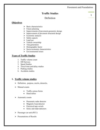
1. Pavement and Foundation
1
Traffic Studies
Definition
Objectives
Basic characteristics
Future planning
Improvements of pavement geometric design
Improvement of pavement structural design
Economic analysis
Safety aspects
Land use
Vehicle ownership
Trip generation
Demographic factor
Socio-economic characteristics
Environmental issues
Types of Traffic Studies
1. Traffic volume count
2. OD Surveys
3. Speed Studies
4. Travel time and delay studies
5. Parking studies
6. Accidents studies
1. Traffic volume studies
Definition, purpose, merits, demerits,
Manual counts
Traffic census forms
Hand tallies
Automatic counts
Pneumatic radar detector
Magnetic loop detector
Electrical tape switch
Sonic and radar detectors
Passenger car unit (PCU)
Presentations of Results
2. Pavement and Foundation
2
2. Speed Studies
Types of speed studies
Spot speed
Percentile speed
Frequency distribution Table
Formula
3. OD Survey
• Purpose
• Methods
Recording registration numbers
Handing postcards to drivers
Road side interviews
Tag-on vehicles survey
Headlight survey
4. Travel Time and Delay Studies
• Definitions
• Methods
License plate method
Test car method
Floating car method
Arrival- output method
5. Parking studies
• Purpose,
• Methods
Select the study area
Carry out a parking inventory in the study area
Carry out a cordon count
Carry out a parking usage study
3. Pavement and Foundation
3
6. Accidents studies
• Purpose
• Accident reporting and recording procedure
Data collection
Need for data collection
Conflicts (intersections)
Traffic Signs
Traffic signs are “any object or device (whether fixed or portable) for conveying to traffic on
road, warnings, information, requirements, restrictions or prohibitions of any description
specified by regulations"
Clear and efficient signing is a key element of traffic engineering.
Road users rely upon signs for information and guidance, whiles highway authorities depend
upon them for efficient working / enforcement of traffic regulations, for traffic management,
and for promotion of road safety.
In order to obtain the greatest efficiency of usage from highway signs in general, and
roadside signs in particular, the following principles should always be borne in mind:
Signs must be designed for anticipated traffic volume and speeds on the roads on
which they are to be used.
Signs should contain only essential information and their significance should be clear
at a glance so that the driver's attention is not distracted from" driving"
Sign-lettering should be clear from sufficiently far away distance.
They should be designed and sited so that, after reading the sign, the driver is left
with sufficient time to undertake any necessary action( s) with safety.
Signs should be effective by day and night.
There are three functional classes of traffic signs, namely
1. Regulatory,
2. Warning and
3. Guide / Informatory Signs.
4. Pavement and Foundation
4
1. Regulatory signs
Regulatory signs give motorists notice of traffic laws or regulations. Such signs designate right-
of-way, indicate speed controls, control movements, regulate parking and control/manage traffic
in various other ways. They are circular in shape, have a red border with a black legend placed
on a white background.
2. Warning sigs
Warning signs direct attention to conditions on highway that are potentially hazardous to traffic
operations.
Such signs require motorists to exercise caution, reduce speed, or make some man oeuvre
in the interest of their own safety or that of other motorists or pedestrians.
These are generally provided near dangerous bends, schools, pedestrian crossings,
converging lanes etc.
Warning signs are distinguished by an equilateral triangle with a red border
encompassing a black symbol - usually a pictogram of the potential hazard -
superimposed on a white background.
5. Pavement and Foundation
5
3. Guide / Informatory signs
Guide / Informatory signs indicate route designations, directions, distances, points of interest
etc.; in short, they help the user along the way.
Unlike most other types, information signs do not lose effectiveness by over-use and
should be erected wherever there is any doubt.
Generally, these type of signs are provided on blue, orthogonal steel plates with a
white border.
The black informatory symbol is placed on a white background for emphasizing the
message.
Traffic Signals
Traffic signals are generally .provided at road intersections and other danger spots.
6. Pavement and Foundation
6
They offer a cost effective solution to all traffic problems at these locations by directing
or warning motorists, cyclists or pedestrians.
In addition, they also serve the following useful functions:
Provide for orderly movement of traffic.
Increase the traffic handling capacity of
intersections.
Reduce the frequency of certain types of
accidents.
Coordinate traffic under conditions of favorable signal spacing (timing), so that it flows
continuously and at definite speeds.
Interrupt heavy traffic to permit crossings by other vehicles or pedestrians
Control traffic lane use.
Interrupt traffic for passage to emergency vehicles such as ambulances, fire fighting
vehicles, etc.
In Pakistan, signals for vehicular control are classed as “pre timed" where specific time
intervals are allocated to the various traffic movements.
Modern traffic signals for intersection control operate on electricity. Individual units must
have separate red, amber and green lenses, 8 to 12" in diameter, each illuminated by its
own light source.
They are mounted on pedestals outside the roadway limits or are suspended above the
intersection by cables or other supports.
For post-mounted signals, minimum and maximum vertical clearances of 15 and 19 feet
are recommended respectively.