
Recommended
More Related Content
Similar to social infrastructure sheet of bairagadh in area appreciation studio
Similar to social infrastructure sheet of bairagadh in area appreciation studio (16)
Recently uploaded
Recently uploaded (20)
social infrastructure sheet of bairagadh in area appreciation studio
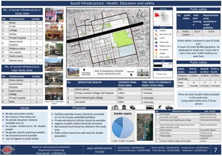
- 1. Social Infrastructure : Health, Education and safety No. of social infrastructure in study area No. Infrastructure number 1 Banks 1 2 A.T.M 1 3 Collage 1 4 School 1 5 Private hospital 1 6 Government hospital 1 7 Religious place 6 8 Fire station 1 9 Public toilets 4 10 Market place 1 Public safety hospital Bank and A.T.M school Public toilet Religious place Fire station college Police station Key map legends 0 50 100m scale Map source Primary survey No. public safety total land coverag e Required land cover according to urdpfi guideline 1 Police station 0.5 H 0.6 H Police station is present in east of study area. It covers for total 90,000 population .its adequate for study area. Crime rate is low in this area. Traffic facilities are poor here Public toilets public toilets first to second Second to third Third to fourth Distance (walking) 0.25km 0.25km 0.27km Time taken 6 minutes 4 minutes 7 minutes There are total 3 public toilets available in the study area. Using public toilets costs 2 Rs per person No. INFRACTURE NEAR BY DISTANCE FROM STUDY AREA TIME TAKEN TO COMMUTE FROM STUDY AREA 1 Police station 50m 2 minutes 2 Chirayu medical collage and hospital 3.4km 7 minutes 3 Sant hirdaram girls collage 500m 5 minutes 4 Axis bank 100m 2 minutes banks users locals traders villagers School of planning and architecture Department of planning Planning lab—II (BPLN0211) AREA APPERCIATION STUDIO 7 Harsh Meena—2022BPLN012 Murali Karthik—2022BPLN010 Pranjali Verma—2022BPLN015 Harshit Somkunwar—2022BPLN008 Sneha Bhuyan– 2022BPLN006 Yokeshwari—2022BPLN014 Issues ➢ No day care center nearby ➢ No nursery in the study area ➢ No private education institute available near by ➢ No proper infrastructure for disable people ➢ No gender specific planning available ➢ No recreational land available ➢ Lack of hygiene in public toilets Proposals ➢ Facilities specially nursery should be accessible in 5 to 10 minutes walk(300mto500m) ➢ Private educational institute should be available ➢ Hygiene in public toilets should be increased ➢ Recreational land should be allotted in the study area ➢ Public toilets should also add seats for disable population No. of social infrastructure near study area No. Infrastructure number 1 Police station 1 2 Government hospital 1 3 Government collage 1 7 Private hospital 1 8 Bank 1 NO. INFRASTRUCTURE NAME DATA SOURCE 1 Civil hospital Shweta Singh(nurse) 2 Seva sadan eye hospital Reena Kumari(nurse) 3 Pandit deen dayal Upadhyay girls collage Niraj Gupta (receptionist) 4 Amar Shahid Hemu Kalani Government Boy's Higher Secondary School Sehej Kumar(teacher) 5 Sub fire station Ramesh(fire fighter) 6 Public toilets Primary survey 7 Police station Ramprasad(sub inspector) 8 Chirayu medical collage and hospital student Sant hirdaram railway station Upper lake MAP OF BAIRAGADH SHOWING SOCIAL INFRASTRUCUTRE Temple Public Toilet Class room in secondary school Fire station Beds in civil hospital Police station 7
- 2. Social Infrastructure : Health, Education and safety School of planning and architecture Department of planning Planning lab—II (BPLN0211) Harsh Meena—2022BPLN012 Murali Karthik—2022BPLN010 Pranjali Verma—2022BPLN015 Harshit Somkunwar—2022BPLN008 Sneha Bhuyan– 2022BPLN006 Yokeshwari—2022BPLN014 ANALYSIS HEALTH There are total two hospital in the area and one in 5km radius EDUCATION There are no day care center in the area and the area of school is inadequate SAFETY Total 28. people working in fire station out of which 4 are fire fighters. Total 26 people are in police station which consist of DSP, sub inspector , inspector and constables RELIGIOUS PLACE There are total five religious places in the area. all of them are temples most of the religious places are maintained by N.G.Os COMPARISION RELIGION STATISTICS HINDU MUSLIM JAINISM CHRISTINITY SIKHISM No. Parameters Requirement according to U.R.D.P.F.I Current scenario Status Population requirement according to U.R.P.F.I Population of study area Status Strength Weakness 1 Health beds Both government and private hospital are there with in 1 km No dispensary in near by area 1.1 Civil hospital 500 350 Adequate 2,50,000 10,000 Adequate 1.2 Seva sadan eye hospital 200 150 Adequate 1,00,000 10,000 Adequate 2 Education Area Both school and collage are present No private school 2.1 Pandit deen dayal Upadhyay girls collage 5 H 0.07 H Adequate 30,000 10,000 Adequate 2.2 Amar Shahid Hemu Kalani Government Boy's Higher Secondary School 3.5 H 2.95H Adequate 15,000 10,000 Adequate 3 Fire safety Radius In the middle of study area 3.1 Sub fire station 3-4km 4km Adequate 50,000 10,000 Adequate 4 Religious place Area Many in numbers 4.1 Julelal mandir 400sqm 66 sqm Adequate 10,000 10,000 Adequate 4.2 Mata temple 400sqm 87sqm Adequate 10,000 10,000 Adequate 4.3 Jay shiv mandir 400sqm 110sqm Adequate 10,000 10,000 Adequate 4.3 Shiv mandir 400sqm 139 sqm Adequate 10,000 10,000 Adequate Remark All the above current scenarios are adequate for the study area and for zone it is compared about PROPOSALS ON MAP Open spaces should be converted into parks and gardens Private educational institute should be introduce in this area as there is need for that Two new nursery should be build in this area AREA APPERCIATION STUDIO 8