1st term answer key
•Download as DOCX, PDF•
0 likes•309 views

Soluciones a los ejercicios de la 1ª evaluación

Recommended
More Related Content
What's hot
What's hot (20)
Similar to 1st term answer key
Similar to 1st term answer key (20)
More from Rubén López
More from Rubén López (20)
Recently uploaded
Recently uploaded (20)
1st term answer key
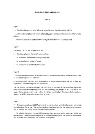
- 1. 1 ESO. FIRST TERM. ANSWER KEY. UNIT 1: Page 8 2 • The Solar System is a term referring to our Sun and the planets that orbit it. • An orbitisthe elliptical movementfollowedbyaplanetorasatellite aroundanothercelestial object. • A satellite is a natural body or artificial object in orbit around a star or planet. Page 9 4 Nitrogen (78.1%) and oxygen (20.9 %). 5 • The lithosphere is the Earth’s solid surface. • The biosphere is the Earth’s ecological system • The atmosphere is a layer of gases. • The hydrosphere is all the Earth’s water Page 10 1 The rotation of the Earth is its movementonits ownaxis in a west-to-eastdirection.Ittakes 24 hours to complete one rotation. 4 The revolutionof the Earth is its movementin an elliptical orbitaroundthe Sun. It takes 365 days and six hours to complete one revolution. 5 Atthe Equator,the Sun’srays reach the Earth close to verticallyall the yearround,sothere is little difference between the seasons. But closer to the poles, the tilt of the Earth on its axis causesthe surface toreceive moreorlessdirectlightfromthe Sun.Thismakesthe hemispheres warmer or colder depending on the time of year. Page 11 7 • The equinoxes (around 21 March and 21 September) are when the Sun’s rays are vertical at the Equator. These mark the beginning of spring and autumn (in the northern hemisphere) and of autumn and spring (in the southern hemisphere). • The solstices(around21 June and 21 December) are whenthe Sun’srays are vertical at one of the tropics. These mark the beginning of summer and winter (in the northern hemisphere) and of winter and summer (in the southern hemisphere).
- 2. • A leap year occurs every four years, when an extra day is added to the month of February. Thiscompensatesforthe factthatourorbitaroundthe Suntakesslightlylongerthanacalendar year: 365 days and six hours. Thus, in a leap year, February has 29 days and the year has 366 days. Page 13 1 The relief (or surface variation) seen on topographic maps reveals features of the natural landscape,suchasmountainsorcanyons,accordingtotheirelevationabove orbelowsealevel. 2 A thematic map gives a visual interpretation of a particular subject (such as climate or population) in the area shown. 4 The Earth can be representedbya three-dimensional globe orona two-dimensional map.A globe offersacomplete andaccurate representation,butislimitedinsize andtherefore detail. A two-dimensional map provides a distorted representation (because the Earth is three- dimensional) but it can focus on an area of any size and may provide great detail. UNIT 2: Page 24 1 The layersof the Earth, beginningwiththe deepest,are:the core (2,900 to 6,000 km beneath the surface);the lowermantle (700to2,900 km);the uppermantle(70to700 km);andthe crust (10 to 70 km thick). Page 25 3 The Earth’s oceans, from largest to smallest, are the Pacific, the Atlantic, the Indian, the Southern, and the Arctic Ocean. The Earth’s continents, from largest to smallest, are Asia, America, Africa, Antarctica, Europe, and Oceania. Page 27 1 Plainsand plateausare flat areas of land.However,plainsare foundat low elevations,often neara coast. Plateausare raisedare raisedareasof land,whichare oftenfoundinmountainous regions.Anislandissurroundedonall sidesbywater,whileapeninsulaismostlysurroundedby water but connected to a larger land mass by a strip called an isthmus.
- 3. Page 29 2 Tectonic plates are the vast blocks that make up the Earth’s crust, like enormous pieces of a jigsaw.There are sevenoreightmajortectonicplates(dependingonhowone definesthem)and many more minor plates. 3 During an eruption, magma (hot liquid rock) rises to the Earth’s surface, moving up the volcano’s main channel, or vent. Once it reaches the Earth’s surface, magma is referred to as lava,whichalongwithashandgasesisejectedthroughanopeninginthe volcanocalledacrater. Lava and rocks accumulate around the volcano and form a cone. Page 31 1 The Earth’s relief canbe modifiedbyinternal forces(suchasvolcanicorseismicactivity) orby external agents, including water and the wind, changes in temperature and human action. UNIT 3: Page 40 2 The types of precipitation include rain, hail, and snow Page 43 1 The uppercourse of a river refersto the fast-movingflow nearestitssource,usuallythrough mountainousareas;the middlecoursereferstothe slowerflowthroughflatterlands,wherethe river meanders around topographical features; the lower course is the flow nearest the river’s mouth, where it is more abundant if tributaries have joined the river. Page 47 3 The three typesof water movementinoceansand seas are: currents,where large massesof watermove like riversthroughlargerbodiesof water,due todifferencesinwatertemperature; tides,the dailyrise andfall of waterlevelsdue tothe gravitational effectsof the Moon;waves, which are surface movements caused by wind. Page 49 5 • A deltais an estuarywitha roughlytriangularshape,asthe riverspreadsout towardsthe sea. • An inland sea is a saltwater lake.
- 4. • Currents are movements of masses of water through water, caused by variations in temperature.Tidesare the rise and fall of waterlevelsdue tothe Moon’sgravitational effects. • Oceans are vast and flow into one another; seas are smaller and contained by land boundaries. • A glacier is an accumulation of snow and ice in a cold, often mountainous region of land. Icebergs are freefloating blocks of ice found in arctic oceans.