Submit Search
Upload
Free and Open Palestine
•
3 likes
•
3,817 views
M
mikel_maron
Follow
State of the Map 2009
Read less
Read more
Report
Share
Report
Share
1 of 44
Download now
Download to read offline
Recommended
OpenStreetMap in Palestine
mikel_maron
OpenStreetMap in Palestine - Mikel Maron
CrisisCommons
Humanitarian OpenStreetMap Team
CrisisCommons
Openstreetmap and its value during emergencies
Ervin Malicdem
Introduction to OpenStreetMap, its extracts, and relation to Project NOAH
Ervin Malicdem
Map Kibera at the UN
mikel_maron
OpenMappingAfrica
OpenMappingAfrica
mikel_maron
OpenStreetMap at Wikimania
mikel_maron
OpenStreetMap at Camp Roberts
mikel_maron
State of the Map Africa by Geoffrey Kateregga
Kateregga Geoffrey
JRC OpenStreetMap, editing and tasking mechanisms, 20130326
Severin Menard
Ieee 2014 tech_training_open_streetmap_20121011
ALCE Samuel Paul
Open streetmap response-to-ebola-crisis-geong-2014-09-23
Pierre Béland
Open Geo Data in Italy and the OpenStreetMap case
Maurizio Napolitano
From geovisualisation to neocartography: Maps in a digital world
Benjamin Hennig
Map kathmandu osm nepal presentation - public
Rajeev Amatya
OpenStreetMap Using, Tools, Services & Hows its changed Humanitarian Response
chippy
How Crowdsourcing Changed Disaster Relief Forever (Web 2.0 Summit Ignite vers...
Schuyler Erle
People powered maps: A population-centric map projection
Benjamin Hennig
HOT OSM Community mapping in Lower Shire, Malawi
Severin Menard
Crowdsource mapping participatory_approach
Oludotun Babayemi
Maps from the Crowd in Crisis context / OpenStreetMap Response to humanitaria...
Pierre Béland
The Golden Age of GIS - Keynote for GIS day 2019
Martijn van Exel
Ramani Huria, East Africa Open Data Conference
Mark Iliffe
ESA Ramani Huria: Mapping for Flood Resilience, Fusing Remote Sensing and Com...
Mark Iliffe
Open Historical Maps: Crowdsourcing, Open Source GIS, and the Research Web
Schuyler Erle
OpenStreetMap Support for Humanitarian Community
Pierre Béland
Leeds Data Thing OpenStreetMap and Other Geo Visualization Stuff
chippy
H.O.T at UNGIWG 10
H.O.T at UNGIWG 10
mikel_maron
Palestine West Bank Free Map Introduction
guest6d104a
More Related Content
What's hot
OpenStreetMap at Camp Roberts
mikel_maron
State of the Map Africa by Geoffrey Kateregga
Kateregga Geoffrey
JRC OpenStreetMap, editing and tasking mechanisms, 20130326
Severin Menard
Ieee 2014 tech_training_open_streetmap_20121011
ALCE Samuel Paul
Open streetmap response-to-ebola-crisis-geong-2014-09-23
Pierre Béland
Open Geo Data in Italy and the OpenStreetMap case
Maurizio Napolitano
From geovisualisation to neocartography: Maps in a digital world
Benjamin Hennig
Map kathmandu osm nepal presentation - public
Rajeev Amatya
OpenStreetMap Using, Tools, Services & Hows its changed Humanitarian Response
chippy
How Crowdsourcing Changed Disaster Relief Forever (Web 2.0 Summit Ignite vers...
Schuyler Erle
People powered maps: A population-centric map projection
Benjamin Hennig
HOT OSM Community mapping in Lower Shire, Malawi
Severin Menard
Crowdsource mapping participatory_approach
Oludotun Babayemi
Maps from the Crowd in Crisis context / OpenStreetMap Response to humanitaria...
Pierre Béland
The Golden Age of GIS - Keynote for GIS day 2019
Martijn van Exel
Ramani Huria, East Africa Open Data Conference
Mark Iliffe
ESA Ramani Huria: Mapping for Flood Resilience, Fusing Remote Sensing and Com...
Mark Iliffe
Open Historical Maps: Crowdsourcing, Open Source GIS, and the Research Web
Schuyler Erle
OpenStreetMap Support for Humanitarian Community
Pierre Béland
Leeds Data Thing OpenStreetMap and Other Geo Visualization Stuff
chippy
What's hot
(20)
OpenStreetMap at Camp Roberts
State of the Map Africa by Geoffrey Kateregga
JRC OpenStreetMap, editing and tasking mechanisms, 20130326
Ieee 2014 tech_training_open_streetmap_20121011
Open streetmap response-to-ebola-crisis-geong-2014-09-23
Open Geo Data in Italy and the OpenStreetMap case
From geovisualisation to neocartography: Maps in a digital world
Map kathmandu osm nepal presentation - public
OpenStreetMap Using, Tools, Services & Hows its changed Humanitarian Response
How Crowdsourcing Changed Disaster Relief Forever (Web 2.0 Summit Ignite vers...
People powered maps: A population-centric map projection
HOT OSM Community mapping in Lower Shire, Malawi
Crowdsource mapping participatory_approach
Maps from the Crowd in Crisis context / OpenStreetMap Response to humanitaria...
The Golden Age of GIS - Keynote for GIS day 2019
Ramani Huria, East Africa Open Data Conference
ESA Ramani Huria: Mapping for Flood Resilience, Fusing Remote Sensing and Com...
Open Historical Maps: Crowdsourcing, Open Source GIS, and the Research Web
OpenStreetMap Support for Humanitarian Community
Leeds Data Thing OpenStreetMap and Other Geo Visualization Stuff
Similar to Free and Open Palestine
H.O.T at UNGIWG 10
H.O.T at UNGIWG 10
mikel_maron
Palestine West Bank Free Map Introduction
guest6d104a
Palestine West Bank Free Map Introduction
mikel_maron
Map Kibera
Map Kibera
mikel_maron
Article25
Article25
Harry Wood
FreeMap Palestine November 2008
mikel_maron
Osm For Sage 20100220
esambale
OSM, GIS and Mapping in Georgia
David Gogishvili
Talk: "Using Open Data and Crowdsourcing to develop CycleStreets"
CycleStreets
Introduction to OpenStreetMap and Humanitarian OSM Team for Plan Internationa...
chippy
Map Kibera at the BreakAway, Nairobi National Museum
mikel_maron
State of Ethiopia 2010
Bandira Addis Map Ent. P.L.C.
GeOng presentation about OpenStreetMap
chippy
OpenStreetMap Brighton 0.9999
mikel_maron
The Implications of OpenStreetMap
Yuwei Lin
[Day 3] Agcommons Quickwin: gRoads
[Day 3] Agcommons Quickwin: gRoads
csi2009
What can Towns learn from OpenStreetMap?
Christian Spanring
Sinsaiinfo4techlionAsKeynote
Taichi Furuhashi
OpenStreetMap, an introduction
Frédéric Rodrigo
Similar to Free and Open Palestine
(19)
H.O.T at UNGIWG 10
H.O.T at UNGIWG 10
Palestine West Bank Free Map Introduction
Map Kibera
Map Kibera
Article25
Article25
FreeMap Palestine November 2008
Osm For Sage 20100220
OSM, GIS and Mapping in Georgia
Talk: "Using Open Data and Crowdsourcing to develop CycleStreets"
Introduction to OpenStreetMap and Humanitarian OSM Team for Plan Internationa...
Map Kibera at the BreakAway, Nairobi National Museum
State of Ethiopia 2010
GeOng presentation about OpenStreetMap
OpenStreetMap Brighton 0.9999
The Implications of OpenStreetMap
[Day 3] Agcommons Quickwin: gRoads
[Day 3] Agcommons Quickwin: gRoads
What can Towns learn from OpenStreetMap?
Sinsaiinfo4techlionAsKeynote
OpenStreetMap, an introduction
More from mikel_maron
Map Kibera Elections Monitoring at ICCM by Kepha Ngito
mikel_maron
OpenStreetMap is Data
mikel_maron
Open Data IOM Haiti, State of the Map
mikel_maron
TechCamp Mumbai OSM Lightning Talk
mikel_maron
OpenStreetMap Deep Dive at FedGeoDay
mikel_maron
Mapping the Invisible
mikel_maron
Geonerdsdc Slum Mapping
mikel_maron
Social Technologies at the GWU Humanitarian Mapping Workshop
mikel_maron
Open Mapping and Community Journalism
mikel_maron
GroundTruth Map Kibera East Coast Tour
mikel_maron
OpenStreetMap and Transport
mikel_maron
Neo-geo-politics
Neo-geo-politics
mikel_maron
Map Kibera
Map Kibera
mikel_maron
OSM Survey tutorial
OSM Survey tutorial
mikel_maron
Map Kibera at Where 2.0
mikel_maron
There is a Kitfox
There is a Kitfox
mikel_maron
InfoActivism 2009 : Intro to Maps
mikel_maron
WaterWiki at Web4Dev09
mikel_maron
OpenStreetMap and UNSDI-t
mikel_maron
Burning Man Earth at Web 2.0 Expo
mikel_maron
More from mikel_maron
(20)
Map Kibera Elections Monitoring at ICCM by Kepha Ngito
OpenStreetMap is Data
Open Data IOM Haiti, State of the Map
TechCamp Mumbai OSM Lightning Talk
OpenStreetMap Deep Dive at FedGeoDay
Mapping the Invisible
Geonerdsdc Slum Mapping
Social Technologies at the GWU Humanitarian Mapping Workshop
Open Mapping and Community Journalism
GroundTruth Map Kibera East Coast Tour
OpenStreetMap and Transport
Neo-geo-politics
Neo-geo-politics
Map Kibera
Map Kibera
OSM Survey tutorial
OSM Survey tutorial
Map Kibera at Where 2.0
There is a Kitfox
There is a Kitfox
InfoActivism 2009 : Intro to Maps
WaterWiki at Web4Dev09
OpenStreetMap and UNSDI-t
Burning Man Earth at Web 2.0 Expo
Free and Open Palestine
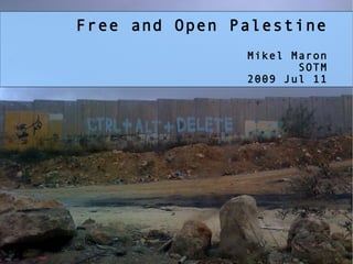
1.
Free and Open
Palestine Mikel Maron SOTM 2009 Jul 11
2.
Complete Roads and POI
in West Bank and Gaza
3.
JumpStart Mapping Palestine
sustainable economic development
4.
Jordan??
5.
we are missing Neutral
Geographic Context http://www.flickr.com/photos/discoste/3069220022/
6.
Bethlehem August 2008 Engineers
without Borders Engineering Association
7.
Testing Our Mapping
Assumptions
8.
Not Easy!
Security/ Heat!/ Volunteers to Job Creation
9.
Cartography
10.
There's no Beyt
Sahour Zoo
11.
Mappers!
12.
From Hebron to
Ramallah to Jenin
13.
Partners Atlas, NC4D, ARIJ,
PCBS, Relief Intl
14.
The State of
the Maps Paper Maps, Geodata Sharing, Piracy
15.
JumpStart is Public
Domain (we ran our own server, tiles, etc)
16.
ESRI tracing, integration, familiarity,
jobs wfs-t interface open up to GIS pros
17.
despite that, Much
happiness
18.
the first “Palestinian Spy
Satellite” (kite photography)
19.
Gaza January 2009 no
decent maps anywhere
20.
Call out for
help
21.
Yahoo! imagery
22.
Tidal wave
23.
Collect existing data
sources and free data UN, Commercial, NGO, EU, Wikipedia, USA, News
24.
OCHA closures, closed
25.
EC, UNOSAT opened
26.
Southern Gaza Remote Mappers,
7 days
27.
Fundraiser for Imagery
5k GBP in days
28.
2m, mid-January from Digital
Globe
29.
JumpStart enters
Gaza in March
30.
local knowledge
31.
Gaza City yesterday
32.
And now...
33.
Import Process from
JumpStart to OSM merge, quality correction talk-ps, talk-il reboot community!
34.
Conflicts? name, name:ar, name:he
settlements
35.
Import to Navteq/TeleAltas,
G-Y-M, UN, etc ?
36.
Applications and Use Map
Cake!
37.
Nationalized Routing
38.
Arabic Maps
39.
InsideGaza, InsideWestBank
40.
SocialGeo
41.
H.O.T Humanitarian OpenStreetMap Team
Tehran - Map Kibera
42.
SOTM Scholarships Anas Maraqa
43.
Complete Roads and POI
in West Bank and Gaza
44.
Thank you!
Mikel Maron mikel@osmfoundation.org http://wiki.openstreetmap.org/wiki/WikiProject_Palestine http://brainoff.com/weblog/index.php?s=gaza+openstreetmap http://jumpstart-mapping.blogspot.com/
Download now