SlideShare a Scribd company logo
1 of 17
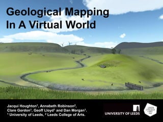
Geological Mapping
In A Virtual World
Jacqui Houghton1, Annabeth Robinson2,
Clare Gordon1, Geoff Lloyd1 and Dan Morgan1.
1 University of Leeds, 2 Leeds College of Arts.
Geological Mapping in a Virtual World
 Update of a web-based mapping
project, from an original paper
exercise on the Moine thrust
geology of NW Scotland.
 Then we discovered Unity and
instead we created…
 A virtual field work environment
which allows training in, and
reinforcement of, mapping skills
in the class room.
 Project consists of three parts:
• Programming – Annabeth
• Geology – Jacqui, Geoff, Dan
• Cartography – Clare
 Virtual landscape populated with
137 ‘outcrops’ each with its own
‘notebook’ entry with information
on the rock characteristics.
 Students plot these on a real
field slip then decide, using the
information provided, which
outcrop to visit next, exercising
the same decision-making skills
as required in the field.
 Create a geological map, cross
sections and stratigraphic
column.
Geological Mapping in a Virtual World
Not a replacement for field work.
 Occupies a virtual space between
the class room and the field.
Learning outcomes
 To become confident in plotting
and interpreting data on a
geological map.
 To understand the decision
making skills involved in
constructing a geological map in
the field in the most time efficient
manner.
 To practice constructing three-
dimensional geological relations,
including drawing cross sections.
Geological Mapping in a Virtual World
 Current opening page
 Enter the field area close to the minibus
 Two minibuses can be used to ‘teleport’ between the hill
and the coast
 Walk pacing – enforces ‘thinking’ time and realism
 GPS (G) gives location for plotting on the map
 Compass (C) is useful as it is easy to lose sense of direction
 Sounds, sheep and the wind farm contextualise and add
realism
 Once close to the outcrop a click brings up the notebook
 Notebook: Details of the rock, fossils and structure
 Measurements then plotted on the field slip and used to
make decision where to go next
 Field slip
 Run in a two hour practical slot
as part of a maps course.
 About 50 second year students,
who had already been on the
mapping training field trip to
Assynt.
 Asked to do a northern transect,
produce a map and cross
section.
 Initial response was a lot more
enthusiastic than we expected
for the gaming generation!
 “I’m enjoying this way more than
is natural…”
The Test Run
 Students were more inclined to
plot readings directly on to their
map than in the field.
 Easier being at a desk and not
needing to record data in
notebook.
 “Outcrop capture” – get ’em on
the map fast; worry about the
geology later. A common field
problem.
 Easier and quicker to ask and
answer questions
 All felt it a good exercise to do
before mapping in the field
The Test Run
Future plans
 This version will be made freely
available on the Web.
 Full model integrated with
teaching at first and second
year level and a refresher at
masters level.
 Alternative assessment for the
mapping trip for students with
mitigating circumstances, with
actual hand specimens rather
than rock descriptions provided.
 Other virtual worlds:
 Engineering geology
 Ecology
 Environmental studies
Any questions…?
j.houghton@leeds.ac.uk Project Lead
annabeth.robinson@leeds-art.ac.uk Serious Game Design
Working with Unity
Working with Unity
Working with Unity
Working with Unity

More Related Content

What's hot

Cyclones in bangladesh
Cyclones in bangladeshCyclones in bangladesh
Cyclones in bangladeshMd Asif Hasan
 
Waves and their significance
Waves and their significanceWaves and their significance
Waves and their significancePramoda Raj
 
Natural hazards & disaster management
Natural hazards & disaster managementNatural hazards & disaster management
Natural hazards & disaster managementAricent Bug
 
Coral reefs and climate change
Coral reefs and climate changeCoral reefs and climate change
Coral reefs and climate changeAbel Henry
 
Introduction to Natural hazards
Introduction to Natural hazardsIntroduction to Natural hazards
Introduction to Natural hazardsSusie Nash
 
Geography: Nuclear Disaster
Geography: Nuclear Disaster Geography: Nuclear Disaster
Geography: Nuclear Disaster Paakhi Bhatnagar
 
Nuclear power ppt
Nuclear power pptNuclear power ppt
Nuclear power pptSami Asokan
 
Ramsar Convention
Ramsar ConventionRamsar Convention
Ramsar Conventionsujit roy
 
About the Bahamas Rocky Shores
About the Bahamas Rocky ShoresAbout the Bahamas Rocky Shores
About the Bahamas Rocky ShoresThe Student Shed
 
KUDANKULAM POWERPLANT by Khan
KUDANKULAM POWERPLANT by KhanKUDANKULAM POWERPLANT by Khan
KUDANKULAM POWERPLANT by KhanKapoorKHAN
 
Seismic vulnerability and risk assessment: case study of the historic city K...
Seismic vulnerability and risk assessment: case study of the historic city  K...Seismic vulnerability and risk assessment: case study of the historic city  K...
Seismic vulnerability and risk assessment: case study of the historic city K...Manish Sharma
 
Coral Reefs: Biodiversity and Beauty at Risk
Coral Reefs: Biodiversity and Beauty at RiskCoral Reefs: Biodiversity and Beauty at Risk
Coral Reefs: Biodiversity and Beauty at RiskMark McGinley
 

What's hot (20)

Cyclones in bangladesh
Cyclones in bangladeshCyclones in bangladesh
Cyclones in bangladesh
 
Lakes of the world
Lakes of the worldLakes of the world
Lakes of the world
 
Waves and their significance
Waves and their significanceWaves and their significance
Waves and their significance
 
Natural hazards & disaster management
Natural hazards & disaster managementNatural hazards & disaster management
Natural hazards & disaster management
 
Coral reefs and climate change
Coral reefs and climate changeCoral reefs and climate change
Coral reefs and climate change
 
Biosphere Notes
Biosphere NotesBiosphere Notes
Biosphere Notes
 
Marine resoues ppt
Marine resoues pptMarine resoues ppt
Marine resoues ppt
 
Introduction to Natural hazards
Introduction to Natural hazardsIntroduction to Natural hazards
Introduction to Natural hazards
 
Geography: Nuclear Disaster
Geography: Nuclear Disaster Geography: Nuclear Disaster
Geography: Nuclear Disaster
 
Natural Disasters
Natural DisastersNatural Disasters
Natural Disasters
 
Nuclear power ppt
Nuclear power pptNuclear power ppt
Nuclear power ppt
 
Ramsar Convention
Ramsar ConventionRamsar Convention
Ramsar Convention
 
About the Bahamas Rocky Shores
About the Bahamas Rocky ShoresAbout the Bahamas Rocky Shores
About the Bahamas Rocky Shores
 
Natural disasters
Natural disastersNatural disasters
Natural disasters
 
KUDANKULAM POWERPLANT by Khan
KUDANKULAM POWERPLANT by KhanKUDANKULAM POWERPLANT by Khan
KUDANKULAM POWERPLANT by Khan
 
Seismic vulnerability and risk assessment: case study of the historic city K...
Seismic vulnerability and risk assessment: case study of the historic city  K...Seismic vulnerability and risk assessment: case study of the historic city  K...
Seismic vulnerability and risk assessment: case study of the historic city K...
 
Cameron Park Trail Map
Cameron Park Trail MapCameron Park Trail Map
Cameron Park Trail Map
 
Ocean waves lecture
Ocean waves lectureOcean waves lecture
Ocean waves lecture
 
Coral Reefs: Biodiversity and Beauty at Risk
Coral Reefs: Biodiversity and Beauty at RiskCoral Reefs: Biodiversity and Beauty at Risk
Coral Reefs: Biodiversity and Beauty at Risk
 
Droughts
DroughtsDroughts
Droughts
 

Viewers also liked

45038163 geological-map-interpretation
45038163 geological-map-interpretation45038163 geological-map-interpretation
45038163 geological-map-interpretationShahnawaz Mustafa
 
Exercise book geological mapping 2015
Exercise book geological mapping 2015Exercise book geological mapping 2015
Exercise book geological mapping 2015Rodrigo Gomes
 
  Information Theory and the Analysis of Uncertainties in a Spatial Geologi...
  Information Theory and the Analysis of Uncertainties in a Spatial Geologi...  Information Theory and the Analysis of Uncertainties in a Spatial Geologi...
  Information Theory and the Analysis of Uncertainties in a Spatial Geologi...The University of Western Australia
 
Geological Maps
Geological MapsGeological Maps
Geological Mapsjohn.payne
 
Creating Content in Second Life
Creating Content in Second LifeCreating Content in Second Life
Creating Content in Second LifeAnnabeth Robinson
 
My Practice - MA Presentation of Staff's Creative Practice
My Practice - MA Presentation of Staff's Creative PracticeMy Practice - MA Presentation of Staff's Creative Practice
My Practice - MA Presentation of Staff's Creative PracticeAnnabeth Robinson
 
Summary map, Strath, Isle of Skye
Summary map, Strath, Isle of SkyeSummary map, Strath, Isle of Skye
Summary map, Strath, Isle of SkyeColeen Murty
 
Geologia estrutural lineações em rocha
Geologia estrutural   lineações em rochaGeologia estrutural   lineações em rocha
Geologia estrutural lineações em rochamarciotecsoma
 
Structural Mapping using GIS/RS
Structural Mapping using GIS/RSStructural Mapping using GIS/RS
Structural Mapping using GIS/RSUmer Khayam
 
11 cartografia geologica
11 cartografia geologica11 cartografia geologica
11 cartografia geologicarailano
 
Paleocurrent analysis
Paleocurrent analysisPaleocurrent analysis
Paleocurrent analysismd5358dm
 

Viewers also liked (20)

45038163 geological-map-interpretation
45038163 geological-map-interpretation45038163 geological-map-interpretation
45038163 geological-map-interpretation
 
Geological mapping(d 13-pg-23)
Geological mapping(d 13-pg-23)Geological mapping(d 13-pg-23)
Geological mapping(d 13-pg-23)
 
AS Geology mapping
AS  Geology mappingAS  Geology mapping
AS Geology mapping
 
Exercise book geological mapping 2015
Exercise book geological mapping 2015Exercise book geological mapping 2015
Exercise book geological mapping 2015
 
  Information Theory and the Analysis of Uncertainties in a Spatial Geologi...
  Information Theory and the Analysis of Uncertainties in a Spatial Geologi...  Information Theory and the Analysis of Uncertainties in a Spatial Geologi...
  Information Theory and the Analysis of Uncertainties in a Spatial Geologi...
 
Geological Maps
Geological MapsGeological Maps
Geological Maps
 
Agenda junio
Agenda junioAgenda junio
Agenda junio
 
Creating Content in Second Life
Creating Content in Second LifeCreating Content in Second Life
Creating Content in Second Life
 
My Practice - MA Presentation of Staff's Creative Practice
My Practice - MA Presentation of Staff's Creative PracticeMy Practice - MA Presentation of Staff's Creative Practice
My Practice - MA Presentation of Staff's Creative Practice
 
Summary map, Strath, Isle of Skye
Summary map, Strath, Isle of SkyeSummary map, Strath, Isle of Skye
Summary map, Strath, Isle of Skye
 
GL4023 Mapping Report finalised
GL4023 Mapping Report finalisedGL4023 Mapping Report finalised
GL4023 Mapping Report finalised
 
Mark Jessell - The topology of geology
Mark Jessell - The topology of geologyMark Jessell - The topology of geology
Mark Jessell - The topology of geology
 
Uncertainty in Geological Mapping - Lachlan Grose (Monash Uni.)
Uncertainty in Geological Mapping - Lachlan Grose (Monash Uni.)Uncertainty in Geological Mapping - Lachlan Grose (Monash Uni.)
Uncertainty in Geological Mapping - Lachlan Grose (Monash Uni.)
 
Geologia estrutural lineações em rocha
Geologia estrutural   lineações em rochaGeologia estrutural   lineações em rocha
Geologia estrutural lineações em rocha
 
John McGaughey - Towards integrated interpretation
John McGaughey - Towards integrated interpretationJohn McGaughey - Towards integrated interpretation
John McGaughey - Towards integrated interpretation
 
Structural Mapping using GIS/RS
Structural Mapping using GIS/RSStructural Mapping using GIS/RS
Structural Mapping using GIS/RS
 
Glacial landforms2
Glacial landforms2Glacial landforms2
Glacial landforms2
 
11 cartografia geologica
11 cartografia geologica11 cartografia geologica
11 cartografia geologica
 
Paleocurrent analysis
Paleocurrent analysisPaleocurrent analysis
Paleocurrent analysis
 
Glacial landforms
Glacial landformsGlacial landforms
Glacial landforms
 

Similar to Geological Mapping Training in Virtual Environment

Geoscience education in digital landscapes: the virtual landscapes project
Geoscience education in digital landscapes: the virtual landscapes projectGeoscience education in digital landscapes: the virtual landscapes project
Geoscience education in digital landscapes: the virtual landscapes projectJisc
 
Mission Space Port Ellen Ps Donated By Jo Clark
Mission Space Port Ellen Ps    Donated By Jo ClarkMission Space Port Ellen Ps    Donated By Jo Clark
Mission Space Port Ellen Ps Donated By Jo ClarkWendy French
 
GPS for Museum Educators
GPS for Museum EducatorsGPS for Museum Educators
GPS for Museum EducatorsJenny Barrett
 
Deeper understanding through Google Earth
Deeper understanding through Google EarthDeeper understanding through Google Earth
Deeper understanding through Google EarthKevin Amboe
 
An Introduction To Field Geology
An Introduction To Field GeologyAn Introduction To Field Geology
An Introduction To Field GeologyBryce Nelson
 
Everyday Engagement with Place
Everyday Engagement with PlaceEveryday Engagement with Place
Everyday Engagement with PlaceGeoBlogs
 
Core Content Coaching Grade 8 Topographic Maps & Satellite Views 14-15
Core Content Coaching Grade 8 Topographic Maps & Satellite Views 14-15Core Content Coaching Grade 8 Topographic Maps & Satellite Views 14-15
Core Content Coaching Grade 8 Topographic Maps & Satellite Views 14-15raegan_witt-malandruccolo
 
Leys Fieldwork Session
Leys Fieldwork SessionLeys Fieldwork Session
Leys Fieldwork SessionGeoBlogs
 
Lesson 4.4 Activity: Fleeing the Surface of the Earth (Part 2)
Lesson 4.4 Activity: Fleeing the Surface of the Earth (Part 2)Lesson 4.4 Activity: Fleeing the Surface of the Earth (Part 2)
Lesson 4.4 Activity: Fleeing the Surface of the Earth (Part 2)Big History Project
 
6 8 inside the earth
6 8 inside the earth6 8 inside the earth
6 8 inside the earthTricia Saba
 
Lesson plan 6th grade
Lesson plan 6th gradeLesson plan 6th grade
Lesson plan 6th grademarthava
 
Geography goes on virtual tour
Geography goes on virtual tourGeography goes on virtual tour
Geography goes on virtual tourGiovanni Donadelli
 
G4 u8 l2_into_the_deep_lesson sl edits
G4 u8 l2_into_the_deep_lesson sl editsG4 u8 l2_into_the_deep_lesson sl edits
G4 u8 l2_into_the_deep_lesson sl editsDr Robert Craig PhD
 
Kindergarten Map and Globes Unit
Kindergarten Map and Globes UnitKindergarten Map and Globes Unit
Kindergarten Map and Globes Unitcchastain427
 
Unit Plan Ci 350
Unit Plan Ci 350Unit Plan Ci 350
Unit Plan Ci 350smiley407a
 
Chastain Angle Final Project
Chastain Angle Final ProjectChastain Angle Final Project
Chastain Angle Final Projectguestadadb4
 

Similar to Geological Mapping Training in Virtual Environment (20)

Geoscience education in digital landscapes: the virtual landscapes project
Geoscience education in digital landscapes: the virtual landscapes projectGeoscience education in digital landscapes: the virtual landscapes project
Geoscience education in digital landscapes: the virtual landscapes project
 
Mission Space Port Ellen Ps Donated By Jo Clark
Mission Space Port Ellen Ps    Donated By Jo ClarkMission Space Port Ellen Ps    Donated By Jo Clark
Mission Space Port Ellen Ps Donated By Jo Clark
 
GPS for Museum Educators
GPS for Museum EducatorsGPS for Museum Educators
GPS for Museum Educators
 
Deeper understanding through Google Earth
Deeper understanding through Google EarthDeeper understanding through Google Earth
Deeper understanding through Google Earth
 
An Introduction To Field Geology
An Introduction To Field GeologyAn Introduction To Field Geology
An Introduction To Field Geology
 
Everyday Engagement with Place
Everyday Engagement with PlaceEveryday Engagement with Place
Everyday Engagement with Place
 
Core Content Coaching Grade 8 Topographic Maps & Satellite Views 14-15
Core Content Coaching Grade 8 Topographic Maps & Satellite Views 14-15Core Content Coaching Grade 8 Topographic Maps & Satellite Views 14-15
Core Content Coaching Grade 8 Topographic Maps & Satellite Views 14-15
 
Geocaching densi2012
Geocaching densi2012Geocaching densi2012
Geocaching densi2012
 
Leys Fieldwork Session
Leys Fieldwork SessionLeys Fieldwork Session
Leys Fieldwork Session
 
Lesson 4.4 Activity: Fleeing the Surface of the Earth (Part 2)
Lesson 4.4 Activity: Fleeing the Surface of the Earth (Part 2)Lesson 4.4 Activity: Fleeing the Surface of the Earth (Part 2)
Lesson 4.4 Activity: Fleeing the Surface of the Earth (Part 2)
 
6 8 inside the earth
6 8 inside the earth6 8 inside the earth
6 8 inside the earth
 
Lesson plan 6th grade
Lesson plan 6th gradeLesson plan 6th grade
Lesson plan 6th grade
 
Global-Trotting
Global-TrottingGlobal-Trotting
Global-Trotting
 
Geography goes on virtual tour
Geography goes on virtual tourGeography goes on virtual tour
Geography goes on virtual tour
 
G4 u8 l2_into_the_deep_lesson sl edits
G4 u8 l2_into_the_deep_lesson sl editsG4 u8 l2_into_the_deep_lesson sl edits
G4 u8 l2_into_the_deep_lesson sl edits
 
Pgqm final presentation
Pgqm final presentationPgqm final presentation
Pgqm final presentation
 
Kindergarten Map and Globes Unit
Kindergarten Map and Globes UnitKindergarten Map and Globes Unit
Kindergarten Map and Globes Unit
 
18. magnetic reversal
18. magnetic reversal18. magnetic reversal
18. magnetic reversal
 
Unit Plan Ci 350
Unit Plan Ci 350Unit Plan Ci 350
Unit Plan Ci 350
 
Chastain Angle Final Project
Chastain Angle Final ProjectChastain Angle Final Project
Chastain Angle Final Project
 

Recently uploaded

INTRODUCTION TO CATHOLIC CHRISTOLOGY.pptx
INTRODUCTION TO CATHOLIC CHRISTOLOGY.pptxINTRODUCTION TO CATHOLIC CHRISTOLOGY.pptx
INTRODUCTION TO CATHOLIC CHRISTOLOGY.pptxHumphrey A Beña
 
Difference Between Search & Browse Methods in Odoo 17
Difference Between Search & Browse Methods in Odoo 17Difference Between Search & Browse Methods in Odoo 17
Difference Between Search & Browse Methods in Odoo 17Celine George
 
Concurrency Control in Database Management system
Concurrency Control in Database Management systemConcurrency Control in Database Management system
Concurrency Control in Database Management systemChristalin Nelson
 
THEORIES OF ORGANIZATION-PUBLIC ADMINISTRATION
THEORIES OF ORGANIZATION-PUBLIC ADMINISTRATIONTHEORIES OF ORGANIZATION-PUBLIC ADMINISTRATION
THEORIES OF ORGANIZATION-PUBLIC ADMINISTRATIONHumphrey A Beña
 
Global Lehigh Strategic Initiatives (without descriptions)
Global Lehigh Strategic Initiatives (without descriptions)Global Lehigh Strategic Initiatives (without descriptions)
Global Lehigh Strategic Initiatives (without descriptions)cama23
 
Field Attribute Index Feature in Odoo 17
Field Attribute Index Feature in Odoo 17Field Attribute Index Feature in Odoo 17
Field Attribute Index Feature in Odoo 17Celine George
 
How to Add Barcode on PDF Report in Odoo 17
How to Add Barcode on PDF Report in Odoo 17How to Add Barcode on PDF Report in Odoo 17
How to Add Barcode on PDF Report in Odoo 17Celine George
 
Active Learning Strategies (in short ALS).pdf
Active Learning Strategies (in short ALS).pdfActive Learning Strategies (in short ALS).pdf
Active Learning Strategies (in short ALS).pdfPatidar M
 
Full Stack Web Development Course for Beginners
Full Stack Web Development Course  for BeginnersFull Stack Web Development Course  for Beginners
Full Stack Web Development Course for BeginnersSabitha Banu
 
Earth Day Presentation wow hello nice great
Earth Day Presentation wow hello nice greatEarth Day Presentation wow hello nice great
Earth Day Presentation wow hello nice greatYousafMalik24
 
Visit to a blind student's school🧑‍🦯🧑‍🦯(community medicine)
Visit to a blind student's school🧑‍🦯🧑‍🦯(community medicine)Visit to a blind student's school🧑‍🦯🧑‍🦯(community medicine)
Visit to a blind student's school🧑‍🦯🧑‍🦯(community medicine)lakshayb543
 
AUDIENCE THEORY -CULTIVATION THEORY - GERBNER.pptx
AUDIENCE THEORY -CULTIVATION THEORY -  GERBNER.pptxAUDIENCE THEORY -CULTIVATION THEORY -  GERBNER.pptx
AUDIENCE THEORY -CULTIVATION THEORY - GERBNER.pptxiammrhaywood
 
ICS2208 Lecture6 Notes for SL spaces.pdf
ICS2208 Lecture6 Notes for SL spaces.pdfICS2208 Lecture6 Notes for SL spaces.pdf
ICS2208 Lecture6 Notes for SL spaces.pdfVanessa Camilleri
 
Q4-PPT-Music9_Lesson-1-Romantic-Opera.pptx
Q4-PPT-Music9_Lesson-1-Romantic-Opera.pptxQ4-PPT-Music9_Lesson-1-Romantic-Opera.pptx
Q4-PPT-Music9_Lesson-1-Romantic-Opera.pptxlancelewisportillo
 
Activity 2-unit 2-update 2024. English translation
Activity 2-unit 2-update 2024. English translationActivity 2-unit 2-update 2024. English translation
Activity 2-unit 2-update 2024. English translationRosabel UA
 
Grade 9 Quarter 4 Dll Grade 9 Quarter 4 DLL.pdf
Grade 9 Quarter 4 Dll Grade 9 Quarter 4 DLL.pdfGrade 9 Quarter 4 Dll Grade 9 Quarter 4 DLL.pdf
Grade 9 Quarter 4 Dll Grade 9 Quarter 4 DLL.pdfJemuel Francisco
 
ECONOMIC CONTEXT - PAPER 1 Q3: NEWSPAPERS.pptx
ECONOMIC CONTEXT - PAPER 1 Q3: NEWSPAPERS.pptxECONOMIC CONTEXT - PAPER 1 Q3: NEWSPAPERS.pptx
ECONOMIC CONTEXT - PAPER 1 Q3: NEWSPAPERS.pptxiammrhaywood
 

Recently uploaded (20)

INTRODUCTION TO CATHOLIC CHRISTOLOGY.pptx
INTRODUCTION TO CATHOLIC CHRISTOLOGY.pptxINTRODUCTION TO CATHOLIC CHRISTOLOGY.pptx
INTRODUCTION TO CATHOLIC CHRISTOLOGY.pptx
 
Difference Between Search & Browse Methods in Odoo 17
Difference Between Search & Browse Methods in Odoo 17Difference Between Search & Browse Methods in Odoo 17
Difference Between Search & Browse Methods in Odoo 17
 
Concurrency Control in Database Management system
Concurrency Control in Database Management systemConcurrency Control in Database Management system
Concurrency Control in Database Management system
 
THEORIES OF ORGANIZATION-PUBLIC ADMINISTRATION
THEORIES OF ORGANIZATION-PUBLIC ADMINISTRATIONTHEORIES OF ORGANIZATION-PUBLIC ADMINISTRATION
THEORIES OF ORGANIZATION-PUBLIC ADMINISTRATION
 
Global Lehigh Strategic Initiatives (without descriptions)
Global Lehigh Strategic Initiatives (without descriptions)Global Lehigh Strategic Initiatives (without descriptions)
Global Lehigh Strategic Initiatives (without descriptions)
 
Field Attribute Index Feature in Odoo 17
Field Attribute Index Feature in Odoo 17Field Attribute Index Feature in Odoo 17
Field Attribute Index Feature in Odoo 17
 
How to Add Barcode on PDF Report in Odoo 17
How to Add Barcode on PDF Report in Odoo 17How to Add Barcode on PDF Report in Odoo 17
How to Add Barcode on PDF Report in Odoo 17
 
Active Learning Strategies (in short ALS).pdf
Active Learning Strategies (in short ALS).pdfActive Learning Strategies (in short ALS).pdf
Active Learning Strategies (in short ALS).pdf
 
Full Stack Web Development Course for Beginners
Full Stack Web Development Course  for BeginnersFull Stack Web Development Course  for Beginners
Full Stack Web Development Course for Beginners
 
FINALS_OF_LEFT_ON_C'N_EL_DORADO_2024.pptx
FINALS_OF_LEFT_ON_C'N_EL_DORADO_2024.pptxFINALS_OF_LEFT_ON_C'N_EL_DORADO_2024.pptx
FINALS_OF_LEFT_ON_C'N_EL_DORADO_2024.pptx
 
Earth Day Presentation wow hello nice great
Earth Day Presentation wow hello nice greatEarth Day Presentation wow hello nice great
Earth Day Presentation wow hello nice great
 
Visit to a blind student's school🧑‍🦯🧑‍🦯(community medicine)
Visit to a blind student's school🧑‍🦯🧑‍🦯(community medicine)Visit to a blind student's school🧑‍🦯🧑‍🦯(community medicine)
Visit to a blind student's school🧑‍🦯🧑‍🦯(community medicine)
 
AUDIENCE THEORY -CULTIVATION THEORY - GERBNER.pptx
AUDIENCE THEORY -CULTIVATION THEORY -  GERBNER.pptxAUDIENCE THEORY -CULTIVATION THEORY -  GERBNER.pptx
AUDIENCE THEORY -CULTIVATION THEORY - GERBNER.pptx
 
ICS2208 Lecture6 Notes for SL spaces.pdf
ICS2208 Lecture6 Notes for SL spaces.pdfICS2208 Lecture6 Notes for SL spaces.pdf
ICS2208 Lecture6 Notes for SL spaces.pdf
 
YOUVE_GOT_EMAIL_PRELIMS_EL_DORADO_2024.pptx
YOUVE_GOT_EMAIL_PRELIMS_EL_DORADO_2024.pptxYOUVE_GOT_EMAIL_PRELIMS_EL_DORADO_2024.pptx
YOUVE_GOT_EMAIL_PRELIMS_EL_DORADO_2024.pptx
 
YOUVE GOT EMAIL_FINALS_EL_DORADO_2024.pptx
YOUVE GOT EMAIL_FINALS_EL_DORADO_2024.pptxYOUVE GOT EMAIL_FINALS_EL_DORADO_2024.pptx
YOUVE GOT EMAIL_FINALS_EL_DORADO_2024.pptx
 
Q4-PPT-Music9_Lesson-1-Romantic-Opera.pptx
Q4-PPT-Music9_Lesson-1-Romantic-Opera.pptxQ4-PPT-Music9_Lesson-1-Romantic-Opera.pptx
Q4-PPT-Music9_Lesson-1-Romantic-Opera.pptx
 
Activity 2-unit 2-update 2024. English translation
Activity 2-unit 2-update 2024. English translationActivity 2-unit 2-update 2024. English translation
Activity 2-unit 2-update 2024. English translation
 
Grade 9 Quarter 4 Dll Grade 9 Quarter 4 DLL.pdf
Grade 9 Quarter 4 Dll Grade 9 Quarter 4 DLL.pdfGrade 9 Quarter 4 Dll Grade 9 Quarter 4 DLL.pdf
Grade 9 Quarter 4 Dll Grade 9 Quarter 4 DLL.pdf
 
ECONOMIC CONTEXT - PAPER 1 Q3: NEWSPAPERS.pptx
ECONOMIC CONTEXT - PAPER 1 Q3: NEWSPAPERS.pptxECONOMIC CONTEXT - PAPER 1 Q3: NEWSPAPERS.pptx
ECONOMIC CONTEXT - PAPER 1 Q3: NEWSPAPERS.pptx
 

Geological Mapping Training in Virtual Environment

  • 1. Geological Mapping In A Virtual World Jacqui Houghton1, Annabeth Robinson2, Clare Gordon1, Geoff Lloyd1 and Dan Morgan1. 1 University of Leeds, 2 Leeds College of Arts.
  • 2. Geological Mapping in a Virtual World  Update of a web-based mapping project, from an original paper exercise on the Moine thrust geology of NW Scotland.  Then we discovered Unity and instead we created…  A virtual field work environment which allows training in, and reinforcement of, mapping skills in the class room.  Project consists of three parts: • Programming – Annabeth • Geology – Jacqui, Geoff, Dan • Cartography – Clare
  • 3.  Virtual landscape populated with 137 ‘outcrops’ each with its own ‘notebook’ entry with information on the rock characteristics.  Students plot these on a real field slip then decide, using the information provided, which outcrop to visit next, exercising the same decision-making skills as required in the field.  Create a geological map, cross sections and stratigraphic column. Geological Mapping in a Virtual World
  • 4. Not a replacement for field work.  Occupies a virtual space between the class room and the field. Learning outcomes  To become confident in plotting and interpreting data on a geological map.  To understand the decision making skills involved in constructing a geological map in the field in the most time efficient manner.  To practice constructing three- dimensional geological relations, including drawing cross sections. Geological Mapping in a Virtual World
  • 6.  Enter the field area close to the minibus  Two minibuses can be used to ‘teleport’ between the hill and the coast  Walk pacing – enforces ‘thinking’ time and realism
  • 7.  GPS (G) gives location for plotting on the map  Compass (C) is useful as it is easy to lose sense of direction  Sounds, sheep and the wind farm contextualise and add realism
  • 8.  Once close to the outcrop a click brings up the notebook  Notebook: Details of the rock, fossils and structure  Measurements then plotted on the field slip and used to make decision where to go next
  • 10.  Run in a two hour practical slot as part of a maps course.  About 50 second year students, who had already been on the mapping training field trip to Assynt.  Asked to do a northern transect, produce a map and cross section.  Initial response was a lot more enthusiastic than we expected for the gaming generation!  “I’m enjoying this way more than is natural…” The Test Run
  • 11.  Students were more inclined to plot readings directly on to their map than in the field.  Easier being at a desk and not needing to record data in notebook.  “Outcrop capture” – get ’em on the map fast; worry about the geology later. A common field problem.  Easier and quicker to ask and answer questions  All felt it a good exercise to do before mapping in the field The Test Run
  • 12. Future plans  This version will be made freely available on the Web.  Full model integrated with teaching at first and second year level and a refresher at masters level.  Alternative assessment for the mapping trip for students with mitigating circumstances, with actual hand specimens rather than rock descriptions provided.  Other virtual worlds:  Engineering geology  Ecology  Environmental studies
  • 13. Any questions…? j.houghton@leeds.ac.uk Project Lead annabeth.robinson@leeds-art.ac.uk Serious Game Design