Loch Skene Glaciated Landscape
•Download as PPTX, PDF•
0 likes•779 views

Case study of glaciated landscape. Landform examples include hanging valleys, moraines, and parabolic glaciated valleys. Maps and diagrams liable to be updated after further fieldwork! Aimed at Higher Grade geography syllabus in Scotland. Individual slides available for download on Flickr. Enjoy. www.flickr.com/photos/geojuice/sets/72157626081928461/

Recommended
Recommended
More Related Content
Viewers also liked
Viewers also liked (19)
More from Alan Doherty
More from Alan Doherty (20)
Recently uploaded
Recently uploaded (20)
Editor's Notes
- The landscape around Loch Skene registers the impact of the severe climate of the Loch Lomond Stadial. Small valley and corrie glaciers developed in the higher hills of the Southern Uplands, and left behind a record of their lifespan in an assemblage of recessional moraines. The Loch Skene glacier was the largest ice mass in the area during the Loch Lomond Readvance but the scale of glaciation was much smaller than thatduring the Late Devensian when the Southern Uplands formed a major centre of ice accumulation.
- Much of the Southern Uplands are comprised of Ordovician and Silurian rocks that were once sands and muds deposited on the floor of the Iapetus Ocean. Deposited over a 70 million year period, between 490 and 420 million years ago, these rocks bear testimony to the closure of the Iapetus Ocean, with the coming together of what is now the North American continent and Northern Europe. This continental collision known as the Caledonian Orogeny joined together the crustal foundations of both Scotland and England. During the collision, sediments were scraped off the floor of Iapetus and heaped onto the edge of the northern continent. At around 400 million years ago, at the start of the Devonian period, there was the intrusion of major granite plutons within the Southern Uplands such as the Criffell granite. The granite in these masses was derived from the actual partial melting of rocks lower within the crust, where the heat and deformation caused by the continental collision was most intense.Two major junctions within Scotland's crustal foundations occur within the area and are associated with the closure of the Caledonian Orogeny and the closure of the Iapetus Ocean. In the south, running in a NE-SW direction under the Solway and border area of Scotland and England, there is the 'Iapetus Suture', which marks the zone of closure of the ancient ocean. Across the top parts of the region, running in a similar NE-SW direction, there is the Southern Uplands Fault, which marks the northern limit of the Southern Uplands and its contact with the Midland Valley. Our case study is in an area of Silurian greywackes.
- Dob’s Linn in Moffat Dale is a gash in the hillside to the north of Loch Skene. It was here that Charles Lapworth, in 1870, established a complete unbroken succession of graptolitic mudstone spanning the Late Ordovician and the Early Silurian Periods. The site has been adopted as the global standard used to define the beginning of the Silurian Period.
- Graptolites are common fossils and have a worldwide distribution. The preservation, quantity and gradual change over a geologic time scale of graptolites allows the fossils to be used to date strata of rocks throughout the world.[1] They are important index fossils for dating Palaeozoic rocks as they evolved rapidly with time and formed many different species. British geologists can divide the rocks of the Ordovician and Silurian periods into graptolite biozones; these are generally less than one million years in duration. A worldwide ice age at the end of the Ordovician eliminated the majority of the then-living graptolite; species present during the Silurian period were the result of diversification from only a one or two species that survived the Ordovician glaciation.
- Graptolites are common fossils and have a worldwide distribution. The preservation, quantity and gradual change over a geologic time scale of graptolites allows the fossils to be used to date strata of rocks throughout the world.[1] They are important index fossils for dating Palaeozoic rocks as they evolved rapidly with time and formed many different species. British geologists can divide the rocks of the Ordovician and Silurian periods into graptolite biozones; these are generally less than one million years in duration. A worldwide ice age at the end of the Ordovician eliminated the majority of the then-living graptolite; species present during the Silurian period were the result of diversification from only a one or two species that survived the Ordovician glaciation.
- The closure of the Iapetus Ocean gave the ocean bed sediments a fairly uniform grain, which in turn influenced the trend of the valleys formed by the erosion over time of the common Ordovician and Silurian rocks.
- The valley of the Moffat Water, the main Valley in this case study area, follows this SW to NE trend, aided by the presence of a major fault.
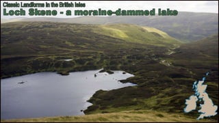
- The hills around Loch Skene rise to an altitude of 822m at White Coomb. The steep headwalls of a corrie enclose the valley at the head of the loch and a second, shallower corrie, drained by the Midlaw Burn, forms a tributary basin to the south-west. A particularly prominent lateral moraine is even marked on the map – “The Causey”.
- The Tail Burn occupies a good example of a hanging valley.
- MidlawCorrie contains a wonderful array of moraines. A full set!
- I think I can “see” another terminal (or lateral) moraine about 500 yards further down the slope from the corrie moraine – just on the other side of the Midlaw Burn. Really need to see this from up on the flanks of White Coomb. Maybe next trip?
- The post-glacial gullies at the head of the MidlawCorrie are worth examination. On the right, a larger drainage area, coupled with greater spring snow melt has produced a post glacial gully of gorge proportions called Midlaw Linn.