Web & Social Media Analytics Previous Year Question Paper.pdf
Pgqm final presentation
1. Section 1: What is geography like in our school?
1a: Achievement is high and pupils make good progress when considered in
relation to age, ability and prior experience
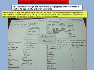
Year 4 samples of work from A River Cruise topic. This was a pupil’s recordings of what he already knew about
rivers and what he’d like to find out at the start of the topic. All teachers use this as a way of informing their
planning to ensure the learning is pitched at the correct level for the class.
2. Pupils should be taught the Knowledge, skills and understanding
through the study of water and its effects on landscapes and
people, including the physical features of rivers.
This pupil is
Pupils should be taught to recognise some physical and human
becoming
processes for example, river erosion.
confident with the
In developing geograhical skills pupils should be taught:
technical
to use appropriate geographical vocabulary and to use
vocabulary
secondary sources of information
associated with
Rivers.
II found it
interesting
finding out about
the different
stages of a river.
3. To draw plans and maps at a range of scales. Pupils
should be taught the knowledge, skills and
Carrying out
understanding through the study of water and its this
effects on landscapes and people, experiment
helped me
I had to follow understand the
instructions to process of the
water cycle
plot onto this
co-ordinates
grid
4. In undertaking geographical enquiry, pupils should be taught to: analyse evidence and draw conclusions. In developing geographical skills, pupils should be taught to
to use appropriate geographical vocabulary. Pupils should be taught the knowledge, skills and understanding through the study of water and its effects on landscapes
and people, including the physical features of rivers and the processes of erosion and deposition that affect them
I understand these This pupil is learning to
processes so much more analyse and understand
after doing this what is happening in
experiment. I could
these physical
actually see all 3
processes and remember
processes. He was
them enthused when he
explained them to me!
5. In undertaking geographical enquiry, pupils should be taught to ask geographical questions , collect and record evidence, analyse evidence
and draw conclusions. In developing geographical skills, pupils should be taught: to use appropriate geographical vocabulary, to use
appropriate fieldwork techniques. Pupils should be taught to: recognise and explain patterns made by individual physical and human
features in the environment and recognise some physical and human processes.
Pupils from
Foundation
stage to Year 6
all carry out
field sketches
when on a
geographical
visit.
I used knowledge learned from the
experiment to spot erosion . in tThe islands in
Transportation had occurred the river slows the
further down the river where it water up because it
was more narrow. I could easily see has to go around it.
evidence of deposition.
6. Velocity is how
many metres
per second the
We used metre water flows.
sticks to measure The quickest
the depth of the was 0.74m/sec
river and tape which links in
measures to with my field
measure the width sketch.
of the river at
various points.
In their studies of localities and themes pupils
should carry out fieldwork investigations outside the
classroom.
7. Class 4’s Spring topic in 2010 was erosion
‘A River Cruise.’ They spent an deposition
exciting day studying the bank
features of a local river.
flow
All staff at Furneux transportation
Pelham School value Why do it?
field work and embrace Children
all opportunities to get remember far
outside and ‘do more
geography’ with their information
classes. when it is hands depth
on. It makes it
real!
velocity
meander
The width of
the river was Children completing a field sketch of
measured at the river. They were told to think
various points carefully about the vocabulary they
along the river. would use to annotate their plans.
These
measurements
were plotted on
the river plan.
8. I found a bug on
the banks of the
river.
The river study was brought to a
close with a mini beast hunt. The
children used key indicators to try
and identify them.
It is small and black. I
couldn’t find it’s
characteristics on the
sheet we were given so
I’m not sure what it
was!
9. Suggested geographical skills/knowledge and other activities to be taught during China week :
Class 2
Class 4
Class 1 Class 2 Class 3 Class 4 Class 5
What comes Where is China? Where is China? Where is China? Where is China?
from/ made in (continents of Which countries Which countries Which countries
China? – find the world) border it? border it? border it?
objects at home. Find Beijing, Find Beijing, Find Beijing,
Children in Where is China? Find Beijing and main rivers and main rivers and main rivers and
Class 1 (continents of main rivers. some other some other some other
learn about the world) cities. cities. cities.
the shapes Look at Flag and Compass Scale work – Locate deserts
of contrasting importance of directions using distance and mountains –
photographs of No. 5 map of China. between cities compare.
features
China eg city vs Climate. etc. Use Sustainability –
via 3D map Farming in China
village and History of the different scales. bio fuels.
work. compare – compare with Olympic Games Grid references Effect of
Animals from UK Invention of the using map of deforestation
China Compass. Beijing. and pollution (see
Chinese counting Directional Uses and Ashden Award
book on animals language using features of the films)
(Enchanted map of Beijing or major rivers. Similarities &
Learning) China Emperor and the differences b/w
Invention of the terracotta army China and the UK
Kite. Silkworm (make replicas?) The Great Wall
Olympic game Extracts Invention of of China
characters Invention of Paper. Foot binding
Silk.
from
debate.
displays
Invention of the
to show Umbrella.
Class 1 progress
achieved
10. 1b Assessment is seen as an essential tool in planning learning and monitoring
pupil progress
Pre-planning of
Papa Westray
topic: the
children were
asked to write
on a slip of
paper what
they already
felt they knew
about this
small Scottish
island. They
were then
asked to think
about what
they would like
to find out. As
their
questions were
answered
through the
term these
were recorded
at the top of
our ‘learning
tree.’
11. What have I learned in Geography this term?
Pupils in Class 2 are asked to explain what geographical
knowledge and skills they have learned at the end of a topic.
I learned how to find places on a
map using coordinates, how to draw Year 2 pupil recording some of the
symbols for features in a key, how geographical learning he
to follow a route on a map and where
the Isle of Coll and the countries of experienced during the topic
the UK are on a map. I used lots of ‘Fantasy Island’.
different words in the topic like
beach, pier, jetty, mountains, loch
and peat.
Pupils were asked to record with pictures and
words what they already knew about our
village for our local studies topic.
12. Assessment of
work completed
during one of our
Topic Weeks.
Teachers assess where they feel the core of their
class are at the end of each term and place these
levels on a foundation subject assessment form. Pupils
exceeding or not reaching this level are also
identified. This then follows the class through each
year.
13. Class 5’s assessed work on Coasts
(2009) to give pupils an
indication of their achievements.
This pupil is confident when
describing the physical and
human features of the coast.
With the use of tickled pink and
green for growth we will be able
to suggest to pupils the next
step in their learning and
geographical understanding.
This pupil has shown through her
work that she understands the
physical processes of erosion and
the effect on our coasts.
14. 1c: Fieldwork, active enquiry learning and the use of ICT has a clear impact on the
way children learn geography.
Wow! I spy a
waterfall in
their garden.
Class 2 (Yr 1&2) children went on a
short journey as part of our Take
One Picture project, studying the
painting Tobias and the Angel. We
wanted to spot as many different
features on the journey and to think
about the differences in landscape
and land use. We would then compare
our journey with the one made by
Tobias.
15. Once back in the classroom we studied the
route on an ordnance survey map and then There are no houses
plotted the different features that they had
noticed on their journey. They were
here – it’s all open and
confident at following routes on a map and you can see a long way
making their own simple maps. They noticed a ahead. I can see trees
lot of features on our journey and could and mud and fields
remember these – sharing their preferences
with the class.
This is a man made
feature but it’s made
from something
natural – wood.
Look at that tunnel
of trees ahead – it
looks exciting!
16. To kick start the Spring Term’s topic on the history of the locality Class 5
took part in the Frederick Soddy Trust’s ‘Go the Extra Mile’ competition.
They walked for a mile in various directions from school, taking note of the
surroundings, land use and features. They then compiled detailed maps to
show their journey and their thoughts on their local environment.
Don’t forget to add
the oak tree and the
road sign by the side
of the house opposite.
Drawing their observations onto
a self drawn map of their route.
Lots of geographical enquiry
as pupils consider how land is
used and possible
improvements that could be
made.
17. The school benefited from having these on
display at school and we were delighted that
one of our pupils won the competition. We
were able to celebrate this achievement as a
whole school. The hedgerows
provide a good
habitat for
I think it is good to
birds and small
have so many fields
mammals.
around here. Lots of
different crops can be
grown for food.
18. Year 5 and
6 pupils
show their
skills at
making their
own maps
with clear
annotations
and keys
19. The winning entry – displaying careful observation and enquiry whilst promoting a
good level of map skills. A keen geographer in the making!
Emma
proudly
shows
off her
prize to
the
Head
Teacher
and
school.
20. Teaching letter and number
co-ordinates linked to the
Katie Morag stories and the
Isle of Strauy on the IWB.
Pupils carrying out activities
on tree identification and
tree habitats during ‘Out and
About’ week.
I wonder
what bugs
are going
The children were excited to be
to try and locate Barnaby You have to go along the here?
Bear using co-ordinates on bottom first, then up!
a map of the Isle of
Strauy.. It made it so
much more real for them!
Max is demonstrating how to find
the position of Barnaby Bear on
the map using co-ordinates.
21. Class 1 sharing their views about the
school environment. Map work is
introduced to Foundation Stage pupils
with the use of aerial photographs
Pupils help to create
a pictogram to show
how they travel to
school
I travel to school
by car because it
is too far to walk.
22. Pupils in Class 4 referred to a
website on world weather to
compare the annual rainfall in
Dublin and in London. (Europe
Week 2009)
Pupils in Class 5 used the internet to research
plants suitable to go in our new pond. They then
used this information to produce an Excel
spreadsheet to display this information clearly.
(Designing a Pond topic 2010)
23. 1d: Geography is seen as a key subject to engage creative and critical thinking
about `people & place’, local and global change and possible futures.
What’s in the
News? Initiative
introduced in 2010.
All children have
the opportunity to
research a recent
and topical news
event, produce a
report on it and
then share their
findings during an
assembly .
24. Examples of
articles written –
children are asked
to find news
events which are
geographical in
nature. They are
encouraged to be
critical in thought
and consider the
impact both
globally and at a
local level.
Work is centrally displayed in school with
the location of world events clearly
displayed.
Holiday Challenge:
During the Christmas
break children were asked
to look out of a window at
home and draw what they
could see. They were
asked to pay attention to
the different features
they could see and think
about how this view
differs at other times of
the year.
25. Geography is engaging creative
and critical thinking about
`people & place’, Clockwise from top: 1. Class 2 pupils
having ‘thinking time’ to consider
what it would be like to live on the
Isle of Coll and the similarities and
differences with living in Furneux
Pelham; 2. Class 4 produced
thought bubbles following role play
to consider the effects of a village
and home becoming flooded and 3.
Group work in Class 2 to consider
which animals might live in the 2
localities of Furneux Pelham and the
Isle of Coll.
26. The old pond was not
interesting. It didn’t
look nice. There were
old brambles and
stinging nettles and
no one used it
Class 4 children spent a term focusing on our old pond and
how they would improve this area of the school grounds.
They completed a lot of cross curricular work and had
visits from gardeners and landscape gardeners to help
with their ideas for pond development. The children
enjoyed the fact that their ideas were taken into
consideration in the final design of the pond and could see
the improvement to the grounds that this made.
I thought stones
would make it look
effective. Emily’s
pond has stones and Mrs
it looks nice. Gravestock
came in to talk
to us about
the design.
She showed us
side and aerial
views and we
devised our
own key
27. 1e: Core geographical knowledge underpins children’s learning about the world.
Each year to
celebrate
International
Day of
Languages, the
whole school
gets involved in
Europe Week.
Each class
chooses a
different
European
country to
study in a
creative and
cross
curricular way.
The main focus
is a
geographical
one, with many
exciting
activities
planned
throughout the
week.
28. Some of the
work
undertaken
by various
age groups
during
Europe
Week to
show that
geographical
knowledge
underpins
their
learning
about the
world.
29. We enjoyed learning
about China and its
features. We learned
how different it was
to our country
We discovered lots of
chinese artefacts at
home. We also found out
that lots of our things are
made in China
30. 1f: Geography supports other curriculum areas, contributes to the enjoyment and
achievement of learners and to whole school initiatives
Class 2 helped to create
this display of the Isle of
Strauy. This reinforced
their knowledge of some of
the island’s features whilst
providing a valuable tool
for geographical work such
as following routes,
devising keys and
comparing two localities.
It also provided
the opportunity to
develop some of
their creative and
artistic skills.
In art we explored manipulating paper to
create our own papier mache island. These
were then used to help us understand how
to use letter/number coordinates to
locate features on a map.
31. Using our knowledge about
the differences between our
own locality and that of the
Isle of Coll we wrote
postcards using 2Publish +
software. Pupils had to
include information about
what we might see or hear on
the island.
Whilst comparing the wildlife found on the Isle of Coll with that found in our own locality the
children had to investigate as a group, where certain animals might be found. This involved
displaying their findings as a Venn Diagram, reinforcing their data handling work in numeracy, as
well as providing great opportunities to develop their thinking and reasoning skills in a group
situation.
Posters and postcards
on display. The
children really
enjoyed creating
these
Clay tiles made in
response to
finding out about
the wildlife on the
island.
32. Pupils compare
temperatures in
different mountain
ranges in numeracy. This shelter is
made from snow and
Pupils produce wood. The snow
insulates the
information texts
shelter and keeps
on different types you warm.
of mountains in
Literacy
As part of a Mountains
topic, the teacher brought
in art and poetry whilst
studying the different
forms of mountains to
create a very eye- catching
display. Class 5 pupils design and make shelters for
mountain dwellers – they had to take into
consideration the specific terrain and
climate where their shelter would be built.
33. . Section 2: Leadership and Management
Through Geography, children at Furneux Pelham
During the last few School will have an understanding of the earth,
years a Vision the physical processes that shape it and the
Statement has evolved. impact that this has on people and places. They
This was written last will be eager to explore their own and other
year and shared with
peoples’ countries and cultures through
staff.
observing and interpreting information about
these environments.
34. 2a There is a `vision’ for geography that is helping to
Pupil voice is seen as a shape the way that the subject is taught. This vision
very important tool by informs the geography policy and guides the writing of
the subject leader in
schemes of work based on the NC. It has the clear
developing the subject
further. See appendix support of the HT and SLT
no.
Since achieving the PGQM award in 2008 at Bronze Furneux Pelham
has come a long way in the teaching of Geography.
CPD in map skills has ensured all staff are more confident with this
important part of geography teaching. There is a clear progression in
the teaching of map skills and staff have recently mapped out when
they will be teaching these to ensure coverage and progression can
take place.
Digital mapping is being used in all classes by staff and pupils. They
are familiar with this and the impact on pupils learning has been
dramatic.
Geography is more respected as a subject in its own right and is
taught as a discrete subject as well as making good cross
curricular links. As a staff we are more able to focus on
geographical appreciation and not just a cultural one when studying
other countries.
We are extremely proud of
one of our pupil’s recent
success in winning a
national competition ‘Go
the Extra Mile’. This has
meant we will have extra
funds to spend on
geography next year, an
achievement we have
celebrated within our
school community.
35. A whole school initiative – Art
in the Environment 2010. To
coincide with National
Grounds Day we decided to
celebrate our school grounds
by turning them into an art
gallery for the day. Each class
were responsible for various
art displays. We invited
parents in to view our work
which had been inspired by
the outdoors.
36. A whole school challenge to design and make a
We are more focused on using our school scarecrow. This was soon after the completion
grounds and local area as a learning resource of a new classroom to our school. The grounds
both in Geography and other subjects. had been a little disrupted and the grounds
men had recently re-seeded part of the field.
We needed some help to protect the ground
from the birds. All entries were erected
outside and the children could see the
importance of looking after our school
environment.
Class 1 & 2 pupils
Pupils hunting for use Barnaby Bear to
Barnaby Bear in the help find out about
village. their local area.
37. CPD was provided
A Guidance Booklet for Staff know what they have to in 2009 on
Geography is in the teach and will seek advice if developing map
process of being unsure. They all teach skills and in 2010
produced. This will according to geography - on Using the
contain the agreed specific learning objectives and School Grounds in
actions for the teaching are very good at using the a Cross-Curricular
of Geography at our correct vocabulary. Pupils know Way. The Subject
school. This is linked to when they are learning Leader has also
the policy and will geography. A range of attended courses
ensure that the resources are centrally located on Using the
teaching and learning of and meetings take place School Grounds
this subject is between teachers at the end and Developing
consistent throughout of the year to aid transition. Gardening.
all classes.
2b Clear and relevant development targets guide
teaching in the school and subject monitoring is focused
on ensuring that the provision has a clear impact on the
progress pupils make, identifies the professional
development needs of staff, supports transition within
and beyond the school and ensures adequate resources
are available for geography.
The subject is monitored by the
Pupil interviews take place on a regular basis to subject leader – planning and work
ascertain the impact on their learning. The sampling takes place to ensure that
pupils are generally enthused about the pupils are making progress.
Geography teaching that takes place and
definitely prefer the hands on approach! Pupils are more aware of the world
around them due to the ‘What’s in the
World?’ scheme. They are able to see
the effects both locally and globally
and are able to empathise with a range
of siuations.
38. The Next Steps....
1. To promote the issue of sustainability. I am keen to make links with other schools
in the area who have already developed a Sustainable Education Curriculum and then
create our own. I would like to initiate a project with the Eco Committee on decreasing
the electricity consumption using the Optimal Monitoring software. On completion of
these two things I would hope that all pupils will be more aware of the importance of
making small changes in order to create a sustainable future.
2. Develop using the Outside Classroom. I would like to ensure that all pupils take full
advantage of our new outside resource. I will work closely with the Science Subject
Leader to develop this area further, providing weather recording equipment and pond
dipping equipment so investigative work can take place. The growing of vegetables has
begun in the raised beds this year and I would like to see this continue with all children
having some involvement throughout the year.
3. Create progression books. Begin to collect examples of map work and other levelled
pieces of Geography work from Reception to Year 6. I feel staff would benefit from
having examples of high quality geography work to make reference to. This will help
everyone to see the route of progression within certain areas of geography teaching.